CA TFR: 06.06.08 - 06.08.08 | Aero-News Network
Aero-News Network
RSS icon RSS feed
podcast icon MP3 podcast
Subscribe Aero-News e-mail Newsletter Subscribe

Airborne Unlimited -- Most Recent Daily Episodes

Episode Date

Airborne-Monday

Airborne-Tuesday

Airborne-Wednesday Airborne-Thursday

Airborne-Friday

Airborne On YouTube

Airborne-Unlimited-10.27.25

AirborneNextGen-
10.28.25

Airborne-Unlimited-10.29.25

Airborne-Unlimited-10.30.25

AirborneUnlimited-10.17.25

Tue, Jun 03, 2008

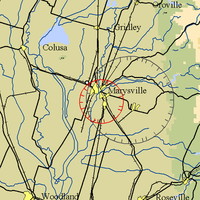
CA TFR: 06.06.08 - 06.08.08

NOTAM Number: FDC 8/9800 
Issue Date: June 02, 2008 at 1057 UTC 
Location: Marysville Yuba County Airport, California near MARYSVILLE VOR/DME (MYV) 
Beginning Date and Time: June 06, 2008 at 2200 UTC 
Ending Date and Time: June 08, 2008 at 2230 UTC 
Reason for NOTAM: High performance aerial demonstrations 
Type: Airshow 
Replaced NOTAM(s): N/A 
Pilots May Contact: Northern California (NCT) TRACON, 916-366-4080 

Affected Area(s)

Airspace Definition: 
  Center: On the MARYSVILLE VOR/DME (MYV) 092 degree radial at 0.2 nautical miles. (Latitude: 39º05'52"N, Longitude: 121º34'11"W)
 Radius: 5 nautical miles
 Altitude: From the surface up to and including 15000 feet MSL
Effective Date(s):
 From June 06, 2008 at 2200 UTC
 To June 06, 2008 at 2359 UTC
 From June 07, 2008 at 2100 UTC
 To June 07, 2008 at 2359 UTC
 From June 08, 2008 at 2000 UTC
 To June 08, 2008 at 2230 UTC

Operating Restrictions and Requirements

No pilots may operate an aircraft in the areas covered by this NOTAM (except as described).

Unless authorized by ATC.

Other Information:

ARTCC: ZOA - Oakland Center
Point of Contact: Mary Hansen
 Telephone 530-682-9003
Authority: Title 14 CFR section 91.145

FMI: www.tfr.faa.gov, Depicted TFR data may not be a complete listing. Pilots should not use the information on this website for flight planning purposes. For the latest information, call your local Flight Service Station at 1-800-WX-BRIEF.

Advertisement

More News

ANN's Daily Aero-Term (10.31.25): Minimum Sector Altitude [ICAO]

Minimum Sector Altitude The lowest altitude which may be used under emergency conditions which will provide a minimum clearance of 300 m (1,000 feet) above all obstacles located in>[...]

ANN's Daily Aero-Linx (10.31.25)

Aero Linx: African Civil Aviation Commission (AFCAC) At AFCAC, our Safety Strategic Objective is to enhance Aviation Safety and the efficiency of Air Navigation Services in Africa.>[...]

NTSB Final Report: Airbus A321-271N (A1); Cessna 172N (A2)

The Local Controller’s Poor Judgment In Prioritization Of Their Ground Traffic Ahead Of Their Airborne Traffic Analysis: Hawaiian Airlines flight 70 (HAL70), N2165HA, an Airb>[...]

ANN FAQ: Follow Us On Instagram!

Get The Latest in Aviation News NOW on Instagram Are you on Instagram yet? It's been around for a few years, quietly picking up traction mostly thanks to everybody's new obsession >[...]

Airborne 10.30.25: Earhart Search, SpaceX Speed Limit, Welcome Back, Xyla!

Also: Beech M-346N, Metro Gains H160 EMS STC, New Bell Boss, Affordable Flying Expo Tickets NOW On Sale! Purdue University’s Research Foundation and the Archaeological Legacy>[...]

blog comments powered by Disqus


Advertisement

Advertisement

Podcasts

Advertisement

© 2007 - 2025 Web Development & Design by Pauli Systems, LC