WorldView-4 Satellite Successfully Launched | Aero-News Network
Aero-News Network
RSS icon RSS feed
podcast icon MP3 podcast
Subscribe Aero-News e-mail Newsletter Subscribe

Airborne Unlimited -- Most Recent Daily Episodes

Episode Date

Airborne-Monday

Airborne-Tuesday

Airborne-Wednesday Airborne-Thursday

Airborne-Friday

Airborne On YouTube

Airborne-Unlimited-06.23.25

Airborne-NextGen-06.24.25

AirborneUnlimited-06.25.25

Airborne-AffordableFlyers-06.26.25

AirborneUnlimited-06.27.25

Tue, Nov 15, 2016

WorldView-4 Satellite Successfully Launched

Lockheed Martin-Built Spacecraft Will Capture Sharp Images From Nearly 400 Miles Above The Earth

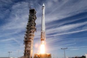
The WorldView-4 commercial remote sensing spacecraft was launched Friday aboard an Atlas V 401 booster. The launch occurred at 10:30 a.m. Pacific Standard Time from Space Launch Complex 3 East from Vandenberg Air Force Base in California.

The launch for DigitalGlobe marked the 137th consecutive successful Atlas launch to date.

The WorldView-4 satellite, built by Lockheed Martin, is the latest in a series of imaging and data satellites for customers around the world. The satellite will capture images so clear that they can distinguish between a sedan, van, and truck from nearly 400 miles in space – the same technology employed on DigitalGlobe’s other WorldView satellites.

DigitalGlobe’s WorldView-3 satellite was also launched on an Atlas from this same location in 2014. The rocket, a United Launch Alliance (ULA) Atlas V 401, was provided by Lockheed Martin Commercial Launch Services. For commercial missions, Lockheed Martin is responsible for contracts, licensing, marketing, sales and mission management of Atlas.

By leveraging DigitalGlobe’s advanced constellation scheduling system to operate in concert with WorldView-3, WorldView-4 will more than double DigitalGlobe’s coverage of the world’s highest-resolution 30 cm commercial satellite imagery and increase the rate at which it grows its 16-year library of time-lapse high-resolution imagery.

WorldView-4 will orbit Earth every 90 minutes, traveling 17,000 miles per hour and capture images equivalent of the land area of Texas each day, according to the company.

(Image provided with Lockheed Martin news release)

FMI: www.lockheedmartin.com

Advertisement

More News

NTSB Final Report: Rutan Long-EZ

He Attempted To Restart The Engine Three Times. On The Third Restart Attempt, He Noticed That Flames Were Coming Out From The Right Wing Near The Fuel Cap Analysis: The pilot repor>[...]

ANN FAQ: Turn On Post Notifications

Make Sure You NEVER Miss A New Story From Aero-News Network Do you ever feel like you never see posts from a certain person or page on Facebook or Instagram? Here’s how you c>[...]

Classic Aero-TV: ICAS Perspectives - Advice for New Air Show Performers

From 2009 (YouTube Edition): Leading Air Show Performers Give Their Best Advice for Newcomers On December 6th through December 9th, the Paris Las Vegas Hotel hosted over 1,500 air >[...]

ANN's Daily Aero-Linx (06.28.25)

Aero Linx: NASA ASRS ASRS captures confidential reports, analyzes the resulting aviation safety data, and disseminates vital information to the aviation community. The ASRS is an i>[...]

Aero-News: Quote of the Day (06.28.25)

“For our inaugural Pylon Racing Seminar in Roswell, we were thrilled to certify 60 pilots across our six closed-course pylon race classes. Not only did this year’s PRS >[...]

blog comments powered by Disqus


Advertisement

Advertisement

Podcasts

Advertisement

© 2007 - 2025 Web Development & Design by Pauli Systems, LC