AirMap Shows Operators Where They Can Fly UAVs | Aero-News Network
Aero-News Network
RSS icon RSS feed
podcast icon MP3 podcast
Subscribe Aero-News e-mail Newsletter Subscribe

Airborne Unlimited -- Most Recent Daily Episodes

Episode Date

Airborne-Monday

Airborne-Tuesday

Airborne-Wednesday Airborne-Thursday

Airborne-Friday

Airborne On YouTube

Airborne-Unlimited-06.10.24

Airborne-NextGen-06.11.24

Airborne-Unlimited-06.12.24 Airborne-FltTraining-06.13.24

Airborne-Unlimited-06.14.24

Thu, May 07, 2015

AirMap Shows Operators Where They Can Fly UAVs

Allows Users To Make Selections Like Proximity To Airports, Airspace Class, TFRs

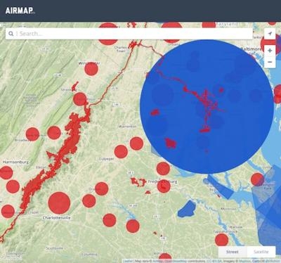
A new website AirMap has been launched and it has valuable information for anyone wanting to operate a UAV. The online map allows users to determine airspace restrictions in the area they’d like to fly an unmanned aircraft. Co-founded by entrepreneur Ben Marcus and drone legal scholar Dr. Gregory McNeal, the website allows the user to make selections, like distance from an airport, class of airspace and temporary flight restrictions.

The site culls multiple sources to provide a single picture of the allowable areas of operation in a region. The current beta version, available at airmap.io, is live in the United States, and an international version is going to launch soon. It focuses on airspace below 500 feet.

"As UAS use continues to expand, the airspace in which operators are flying is also growing more complex. With this in mind, we've launched AirMap, which will serve as a resource for drone operators to immediately fly safely and in compliance with legal requirements. We want to make safe flying easy," says Marcus.
"As a drone operator, I found it hard to know what the airspace rules were in the places where I wanted to fly,” says McNeal. “There were no accurate visuals or reliable electronic tools that could tell me and other operators where we can and cannot fly. AirMap solves this problem and helps to educate operators about this complex regulatory environment. The demand for AirMap is clear, as it is the most thorough resource for drone operators to ensure safe, legal and hassle-free flight."

(Image provided by AirMap)

FMI: www.airmap.io

Advertisement

More News

ANN FAQ: Submit a News Story!

Have A Story That NEEDS To Be Featured On Aero-News? Here’s How To Submit A Story To Our Team Some of the greatest new stories ANN has ever covered have been submitted by our>[...]

Aero-News: Quote of the Day (06.12.24)

“The legislation now includes a task force with industry representation ensuring that we have a seat at the table and our voice will be heard as conversations about the futur>[...]

ANN's Daily Aero-Linx (06.12.24)

Aero Linx: Waco Museum The WACO Historical Society, in addition to preserving aviation's past, is also dedicated and actively works to nurture aviation's future through its Learnin>[...]

ANN's Daily Aero-Term (06.12.24): Adcock Range

Adcock Range National low-frequency radio navigation system (c.1930-c.1950) replaced by an omnirange (VOR) system. It consisted of four segmented quadrants broadcasting Morse Code >[...]

Airborne Affordable Flyers 06.06.24: 200th ALTO, Rotax SB, Risen 916iSV

Also: uAvionix AV-Link, Does Simming Make Better Pilots?, World Games, AMA National Fun Fly Czech sportplane manufacturer Direct Fly has finished delivering its 200th ALTO NG, the >[...]

blog comments powered by Disqus


Advertisement

Advertisement

Podcasts

Advertisement

© 2007 - 2024 Web Development & Design by Pauli Systems, LC