Airbus To Develop CO3D Earth Observation Program For CNES | Aero-News Network
Aero-News Network
RSS icon RSS feed
podcast icon MP3 podcast
Subscribe Aero-News e-mail Newsletter Subscribe

Airborne Unlimited -- Most Recent Daily Episodes

Episode Date

Airborne-Monday

Airborne-Tuesday

Airborne-Wednesday Airborne-Thursday

Airborne-Friday

Airborne On YouTube

Airborne-Unlimited-11.10.25

AirborneNextGen-
11.11.25

Airborne-Unlimited-11.12.25

Airborne-Unlimited-11.06.25

AirborneUnlimited-11.07.25

LIVE MOSAIC Town Hall (Archived): www.airborne-live.net

Mon, Jul 15, 2019

Airbus To Develop CO3D Earth Observation Program For CNES

Strategic Move To Support Export Contracts For French Industry

The French Space Agency (CNES) has awarded the CO3D (Constellation Optique 3D) contract to Airbus. Under this agreement, Airbus will deliver a global high-resolution Digital Surface Model (DSM).

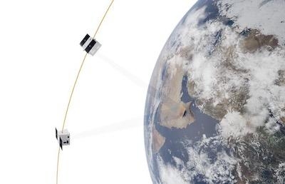
Following launch, expected end of 2022, the Airbus-made CO3D constellation, comprising four identical satellites, will deliver 50cm resolution stereo imagery across the world on a daily basis. The data acquired will feed a cloud-based processing chain operated by Airbus and integrating CNES’ algorithms, to produce a cutting-edge 3D map of the Earth’s landmass.

Designed to weigh approximately 300kg (approx. 660 pounds), the CO3D satellites will join Airbus’ fleet of optical and radar satellites, strengthening the company’s ability to meet the growing needs of very demanding applications. Inaugurating a generation of highly innovative and all electric platforms, these extremely agile satellites will instigate a new way of acquiring, processing and transferring images to the ground. Together with the four Pléiades Neo satellites, the CO3D constellation will offer unrivalled refresh rates for very high-resolution imagery.

“CO3D is a significant leap forward for global Earth observation, taking advantage of the latest Airbus innovations which will revolutionise access to very high-resolution 3D data” said Jean-Marc Nasr, Head of Space Systems at Airbus. “This contract confirms Airbus as the trusted partner for CNES and the French Authorities, and reinforces our leading market position in Europe and the world.”

CNES and Airbus have established a virtuous partnership with this project. An integrated and agile governance between both partners will enable the mission to be optimised to cover both private and public needs. Data collected by the CO3D constellation will be available for scientific and defence institutional partners of the program.

"The new generation optical satellite constellation CO3D embodies French ambition and ingenuity and opens a new era for Earth observation," said Jean-Yves Le Gall, president of CNES. "It will allow a higher refresh rate, improved performance and better resilience. This partnership between CNES and Airbus perfectly illustrates  French excellence in Earth observation from space.”

(Image provided with Airbus news release)

FMI: www.airbus.com

Advertisement

More News

ANN FAQ: Contributing To Aero-TV

How To Get A Story On Aero-TV News/Feature Programming How do I submit a story idea or lead to Aero-TV? If you would like to submit a story idea or lead, please contact Jim Campbel>[...]

Classic Aero-TV: Bob Hoover At Airventure -- Flight Test and Military Service

From 2011 (YouTube Edition): Aviation's Greatest Living Legend Talks About His Life In Aviation (Part 5, Final) ANN is pleased to offer you yet another snippet from the public conv>[...]

Aero-News: Quote of the Day (11.12.25)

“All Air Traffic Controllers must get back to work, NOW!!! Anyone who doesn’t will be substantially ‘docked. For those Air Traffic Controllers who were GREAT PATR>[...]

ANN's Daily Aero-Linx (11.12.25)

Aero Linx: American Navion Society Welcome to the American Navion Society. Your society is here to support the Navion community. We are your source of technical and operating infor>[...]

ANN's Daily Aero-Term (11.12.25): Glideslope Intercept Altitude

Glideslope Intercept Altitude The published minimum altitude to intercept the glideslope in the intermediate segment of an instrument approach. Government charts use the lightning >[...]

blog comments powered by Disqus


Advertisement

Advertisement

Podcasts

Advertisement

© 2007 - 2025 Web Development & Design by Pauli Systems, LC