Hurricane Henri Is Approaching the Northeast | Aero-News Network
Aero-News Network
RSS icon RSS feed
podcast icon MP3 podcast
Subscribe Aero-News e-mail Newsletter Subscribe

Airborne Unlimited -- Most Recent Daily Episodes

Episode Date

Airborne-Monday

Airborne-Tuesday

Airborne-Wednesday Airborne-Thursday

Airborne-Friday

Airborne On YouTube

Airborne-Unlimited-06.17.24

Airborne-NextGen-06.18.24

Airborne-Unlimited-06.12.24 Airborne-FltTraining-06.13.24

Airborne-Unlimited-06.14.24

Sun, Aug 22, 2021

Hurricane Henri Is Approaching the Northeast

NYC Declares State Of Emergency

Keep your eyes on the weather this weekend, if you are flying in the Northeast, as Hurricane Henri approaches the area.

Henri was upgraded from a tropical storm to a hurricane on Saturday. The storm brings with it heavy winds, rain, and storm surge. The hurricane is likely to make landfall between Long Island and Southern New England Sunday.
The National Weather Service reports the most likely time of arrival of tropical-storm-force winds for southern New England to be Sunday morning.

New York City Mayor Bill de Blasio declared a state of emergency Saturday afternoon ahead of the storm. Residents of the Northeast should keep in mind that the area is already deeply saturated and a call has been put out to be aware of potential flooding. Henri is a slow-moving system that is set to leave a lot of rain in its path.

Narragansett Bay and the south coasts of RI and MA are most likely to be affected by the surge flooding, while CT and western and central MA are most at risk for rainfall flooding.

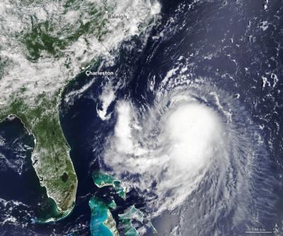
With this storm system, New England is facing its first direct hurricane landfall in thirty years. According to an image acquired from NASA’s Terra satellite at 11:45 AM ET on August 20, 2021, Henri was located about 400 miles southeast of Charleston, SC moving northwest. Sustained winds measured 65 miles per hour, 9 miles short of a category-1 hurricane.

As of 17:00 ET Saturday, Hurricane Henri was located 335 miles south of Montauk Point, NY with 75mph winds and moving north at 18 mph.

FWI: www.weather.gov/box/tropical

Advertisement

More News

ANN FAQ: Submit a News Story!

Have A Story That NEEDS To Be Featured On Aero-News? Here’s How To Submit A Story To Our Team Some of the greatest new stories ANN has ever covered have been submitted by our>[...]

Aero-News: Quote of the Day (06.12.24)

“The legislation now includes a task force with industry representation ensuring that we have a seat at the table and our voice will be heard as conversations about the futur>[...]

ANN's Daily Aero-Linx (06.12.24)

Aero Linx: Waco Museum The WACO Historical Society, in addition to preserving aviation's past, is also dedicated and actively works to nurture aviation's future through its Learnin>[...]

ANN's Daily Aero-Term (06.12.24): Adcock Range

Adcock Range National low-frequency radio navigation system (c.1930-c.1950) replaced by an omnirange (VOR) system. It consisted of four segmented quadrants broadcasting Morse Code >[...]

Airborne Affordable Flyers 06.06.24: 200th ALTO, Rotax SB, Risen 916iSV

Also: uAvionix AV-Link, Does Simming Make Better Pilots?, World Games, AMA National Fun Fly Czech sportplane manufacturer Direct Fly has finished delivering its 200th ALTO NG, the >[...]

blog comments powered by Disqus


Advertisement

Advertisement

Podcasts

Advertisement

© 2007 - 2024 Web Development & Design by Pauli Systems, LC