SmarTopo Harvest Develops A 'Safe Zone' For UAVS | Aero-News Network
Aero-News Network
RSS icon RSS feed
podcast icon MP3 podcast
Subscribe Aero-News e-mail Newsletter Subscribe

Airborne Unlimited -- Most Recent Daily Episodes

Episode Date

Airborne-Monday

Airborne-Tuesday

Airborne-Wednesday Airborne-Thursday

Airborne-Friday

Airborne On YouTube

Airborne-Unlimited-06.10.24

Airborne-NextGen-06.11.24

Airborne-Unlimited-06.12.24 Airborne-FltTraining-06.13.24

Airborne-Unlimited-06.14.24

Tue, Mar 31, 2015

SmarTopo Harvest Develops A 'Safe Zone' For UAVS

New Obstacle Detection Technology For The SmarTopo Obstacle Management System

Rapid Imaging Software, Inc. introduced SmarTopo Harvest on Monday. This new technology is integrated into the SmarTopo Obstacle Management System. SmarTopo delivers obstacle survey and detection technology plus powerful data management tools for a complete obstacle management system. SmarTopo is certified by the FAA to a level 1B.

Mike Abernathy, Director of Development notes, “SmarTopo Harvest is the key for small commercial drones to operate safely in urban areas. This technology allows companies to create and maintain an obstacle database for their drone operations."

SmarTopo Harvest is the latest obstacle detection technology from Rapid Imaging Software. The software provides a fast and efficient method to detect undocumented obstacles and add new obstacles to a database.

  • Searches for obstacles – the height for the search is set by the analyst
  • Detected objects or structures may be compared to the FAA obstacle database
  • Estimates height of the objects or structures
  • Creates new obstacle for a proprietary database

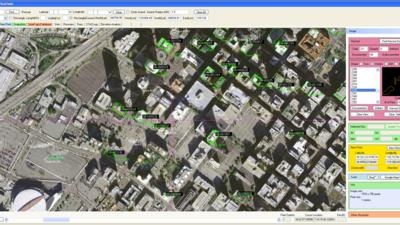
The issue of undocumented obstacles is extensive. A recent study conducted using SmarTopo Harvest indicates there are a substantial number of undocumented obstacles in the national airspace. An analyst using SmarTopo Harvest identified 52 undocumented obstacles of 200 feet or more in a study area of six square miles around the Los Angeles International Airport.

(Image provided by Rapid Imaging Software)

FMI: www.rapidimaging.net/obstaclemanagement/

Advertisement

More News

ANNouncement: Now Accepting Applications For Oshkosh 2024 Stringers!!!

An Amazing Experience Awaits The Chosen Few... Oshkosh, to us, seems the perfect place to get started on watching aviation recover the past couple of years... and so ANN is putting>[...]

Aero-News: Quote of the Day (06.13.24)

“NBAA has a tremendous responsibility to the business aviation industry, and we are constantly collaborating with them. Our flight departments, professionals and aircraft own>[...]

ANN's Daily Aero-Term (06.13.24): Dead Reckoning

Dead Reckoning Dead reckoning, as applied to flying, is the navigation of an airplane solely by means of computations based on airspeed, course, heading, wind direction, and speed,>[...]

ANN's Daily Aero-Linx (06.13.24)

Aero Linx: Vertical Aviation Safety Team (VAST) We are a public–private initiative to enhance worldwide flight operations safety in all segments of the vertical flight indust>[...]

ANN FAQ: How Do I Become A News Spy?

We're Everywhere... Thanks To You! Even with the vast resources and incredibly far-reaching scope of the Aero-News Network, every now and then a story that should be reported on sl>[...]

blog comments powered by Disqus


Advertisement

Advertisement

Podcasts

Advertisement

© 2007 - 2024 Web Development & Design by Pauli Systems, LC