Fri, Feb 24, 2012
NASA-Derived Technology Enables Accurate Volcanic-Ash
Assessment At Airport In Argentina
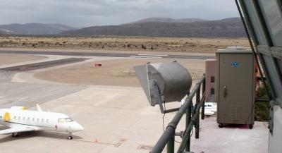
At the request of the Argentinean Ministry of Defense, a LiDAR
system developed by Sigma Space was installed at Bariloche airport
in Argentina on January 30th. Since the June 2011 eruption of the
Chilean Puyehue, Bariloche has been suffering from intermittent ash
clouds blowing from the volcano, and the airport in Bariloche has
been closed much of the time since the eruption. Sigma
Space’s portable and highly automated Micro Pulse LiDAR (MPL)
system was able to be rapidly deployed.
Volcanic ash has been a recurrent impediment to normal
air-traffic operations in Europe, Asia and South America over the
last few years. Sigma’s MPL permits determination of ash
concentration profile every few seconds. "With the new equipment,
companies will have an accurate picture of ash clouds, which will
enable them to cancel flights only in extreme conditions of
concentration of particles in the air," said Hector Ciappesoni,
director of the Meteorological Service of Argentina.
"This equipment brings the airport to the highest safety
standards," said Rio Negro governor Alberto Weretilneck. He
highlighted that the quick response of the Defense Ministry to the
order of the President, Cristina Fernandez de Kirchner, enabled the
airport to operate normally since procuring the LiDAR.
Marcos Sirota, president of Sigma Space and an Argentina native,
traveled to Bariloche to personally supervise the installation of
the MPL. “After calibration we will be able to provide
quantitative information in real time. LiDAR networks will be able
to report both vertical and regional ash distribution worldwide. A
true breakthrough for aviation,” he said.
The World Meteorological Association (WMO) is developing new
standards for the incorporation of LiDAR information into regular
forecasts worldwide, as LiDAR measurements could provide a
comprehensive assessment of ash distribution in flight corridors.
Sigma Space Corporation produces pioneering LiDAR instrumentation,
laser ranging, attitude determination, spectroscopy, and radiometry
for remote sensing and defense applications. Sigma Space also
supplies advanced science and engineering services to government
customers. (Photo provided by Sigma Space)
More News
The Airplane Made An Uncommanded Right Yaw And Roll, And He Was Unable To Maintain Control Of The Airplane On November 11, 2025, about 1750 central standard time, a Cirrus SR20, N8>[...]
Aero Linx: Florida Antique Biplane Association "Biplanes.....outrageous fun since 1903." That quote really defines what the Florida Antique Biplane Association (FABA) is all about.>[...]
Wind Shear Escape An unplanned abortive maneuver initiated by the pilot in command (PIC) as a result of onboard cockpit systems. Wind shear escapes are characterized by maximum thr>[...]
“Working closely with the Polish Armed Forces, we’re focused on disciplined execution to help enhance Poland’s defense capabilities and keep up with the strong de>[...]
Also: Bell 505 on SAF, NYPA Gets Flak For BizAv 'Abuse', FAA Venezuela Caution, Horizon Update Textron Aviation has confirmed it will be ending production of the Beechcraft Bonanza>[...]
 NTSB Prelim: Cirrus Design Corp SR20

