ScanEagle Proves Effective As A Wildfire Suppression Resource | Aero-News Network
Aero-News Network
RSS icon RSS feed
podcast icon MP3 podcast
Subscribe Aero-News e-mail Newsletter Subscribe

Airborne Unlimited -- Most Recent Daily Episodes

Episode Date

Airborne-Monday

Airborne-Tuesday

Airborne-Wednesday Airborne-Thursday

Airborne-Friday

Airborne On YouTube

Airborne-Unlimited-06.17.24

Airborne-NextGen-06.18.24

Airborne-Unlimited-06.12.24 Airborne-FltTraining-06.13.24

Airborne-Unlimited-06.14.24

Thu, Aug 23, 2018

ScanEagle Proves Effective As A Wildfire Suppression Resource

Aircraft Deployed In Oregon With Manned Aviation Firefighting Teams

Insitu has been helping firefighters on wildfires in Oregon, providing information for fire suppression activities via its data collection, analysis and delivery capabilities.

Comprised of aviation professionals, Insitu's Mobile Response Team has been operating its ScanEagle Unmanned Aerial System (UAS) to supplement manned aviation firefighting teams battling wildland fires. ScanEagle is a licensed and approved UAS operating in full compliance with FAA regulations and with the full approval of local, state and federal fire authorities.

A UAS team working on a fire consists of a vendor flight crew, as well as federal personnel who work together to meet the incident goals and objectives. The UAS Manager (a federal employee) provides the required communication between air and ground resources to facilitate safe and effective missions, while the Data Specialist (also a federal employee) works directly with the vendor flight crew and incident GIS Specialist (GISS) to ensure timely development/delivery of requested data products.

The ScanEagle teams "fly the gaps," meaning they fly the UAS at night and over dense smoke and inversion conditions, when manned aircraft typically are grounded due to hazardous conditions for pilots. The ScanEagle team to date has logged more than 200 hours of night flight time during nearly 30 flights over the Garner Complex and Taylor Creek fires in Oregon.

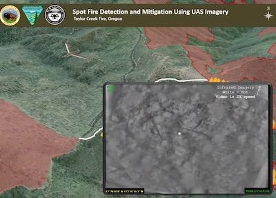
The payload onboard the ScanEagle includes infrared sensors and electro-optical cameras that gather and disseminate geospatial imagery, and provide incident perimeter maps and full motion video. The sensors and cameras spot heat signatures, fire movement and spot fires, and provide video feed of critical infrastructure, historical buildings and other structures that might be in danger, as well as identifying safe ingress and egress routes for firefighters.

"Above all, our main mission is to help combat these unrelenting fires and help keep the firefighters, the residents and the communities safe," explained Andrew Duggan, vice president, Insitu Commercial. "One of the benefits of flying UAS over difficult and rugged terrain is mitigating the need for firefighters to physically walk it when locating and extinguishing hot spots," he continued. "By flying UAS at night, fire incident commanders have the advantage of significant fire intelligence and heightened situational awareness for their early morning planning meetings in determining where to most effectively and safely dispatch their resources and personnel."

All ScanEagle UAS flights have been coordinated with the Oregon Department of Forestry (ODF), the Federal Aviation Agency (FAA) and the Department of the Interior (DOI).

(Image from BLM YouTube video)

FMI: insitu.com

Advertisement

More News

ANN FAQ: Submit a News Story!

Have A Story That NEEDS To Be Featured On Aero-News? Here’s How To Submit A Story To Our Team Some of the greatest new stories ANN has ever covered have been submitted by our>[...]

Aero-News: Quote of the Day (06.12.24)

“The legislation now includes a task force with industry representation ensuring that we have a seat at the table and our voice will be heard as conversations about the futur>[...]

ANN's Daily Aero-Linx (06.12.24)

Aero Linx: Waco Museum The WACO Historical Society, in addition to preserving aviation's past, is also dedicated and actively works to nurture aviation's future through its Learnin>[...]

ANN's Daily Aero-Term (06.12.24): Adcock Range

Adcock Range National low-frequency radio navigation system (c.1930-c.1950) replaced by an omnirange (VOR) system. It consisted of four segmented quadrants broadcasting Morse Code >[...]

Airborne Affordable Flyers 06.06.24: 200th ALTO, Rotax SB, Risen 916iSV

Also: uAvionix AV-Link, Does Simming Make Better Pilots?, World Games, AMA National Fun Fly Czech sportplane manufacturer Direct Fly has finished delivering its 200th ALTO NG, the >[...]

blog comments powered by Disqus


Advertisement

Advertisement

Podcasts

Advertisement

© 2007 - 2024 Web Development & Design by Pauli Systems, LC