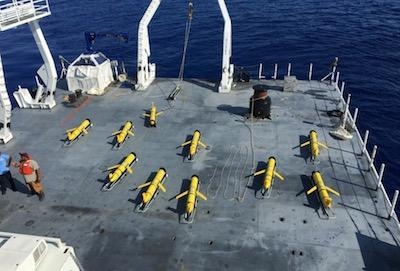
Twelve Aircraft Currently Deployed In The Tropical Atlantic Region
The Naval Meteorology and Oceanography Command (CNMOC), in cooperation with the National Oceanic and Atmospheric Administration (NOAA), launched an ongoing operation last week to introduce Navy unmanned underwater vehicles, also known as Littoral Battlespace Sensing (LBS) gliders, into areas of known hurricane development tracks in the Atlantic Ocean and Caribbean Sea.
"As the Navy's leader in unmanned underwater vehicles, we're proud to partner with NOAA to deploy and control Navy ocean gliders this summer," said Rear Adm. John Okon, commander, Naval Meteorology and Oceanography Command. “Our partnership has a long and rich history of collaboration; however, this is the first time Navy ocean gliders will be placed in advance of historical tropical cyclone tracks to collect critical oceanographic information in real-time."
These sensors can be placed into the path of developing systems and have the ability to profile the ocean's temperature and salinity to provide information regarding the heat transfer between the ocean and the overlying atmosphere. The collected temperature data can then be fed into high performance atmospheric and oceanographic models to help improve hurricane intensity forecasts. "The oceanographic observations will improve our understanding of the heat content of the upper portion of the ocean, critical to understanding how intense tropical systems might become. The area where NOAA deployed the gliders has a high probability of being in a location of a developing tropical system and the observations will have significant impacts on understanding the storm's development and intensity," said Okon.
NOAA's National Data Buoy Center is assisting with this effort by ensuring the environmental data collected from these gliders, along with the NOAA gliders in the program, will be disseminated through the Glider Data Assembly Center to the world's Global Telecommunications System. The gliders are piloted by the Naval Oceanographic Office's Glider Operations Center, located at Stennis Space Center, Mississippi, which is the nation's only round-the-clock center piloting up to 100 gliders at a time. "The gliders are being deployed and recovered through academic partnerships; however, they are being remotely piloted and monitored around the clock, seven days a week by the experts at the Naval Oceanographic Office's Glider Operations Center," said NOAA Corps officer Cmdr. Jason Mansour, the NOAA liaison to the Oceanographer of the Navy. "This is an outstanding example of interagency cooperation with the Department of the Navy and the Department of Commerce are capable of."
Nine Navy gliders and three NOAA gliders are currently deployed in the tropical Atlantic. These real-time oceanographic observations will assist in improving forecasts for both Navy and NOAA activities. "Improved tropical cyclone intensity predictions are critical for the safety of the Navy's fleet, and the prediction of critical resources for the Department of the Navy and our Nation," said Okon.
The Naval Meteorology and Oceanography Command directs and oversees more than 2,500 globally-distributed military and civilian personnel who collect, process and exploit environmental information to assist fleet and joint commanders in all warfare areas to make better decisions faster than the adversary.
The Naval Oceanographic Office is comprised of approximately 800 military, civilian and contractor personnel. The Oceanographic Office uses a variety of platforms, including ships, aircraft, satellite sensors, buoys and unmanned underwater vehicles, to collect oceanographic and hydrographic data from the world's oceans.
The Oceanographer of the Navy is a key advisor to the chief of Naval Operations who provides naval leadership on issues related to oceanography, meteorology, hydrography, precise time, and geospatial and celestial referencing. The oceanographer also serves as the senior policy advisor for issues related to national ocean policy and governance.
(Image provided with U.S. Navy news release)
 Aero-News: Quote of the Day (05.20.25)