Topcon Announces Next Generation Flight Planning Software | Aero-News Network
Aero-News Network
RSS icon RSS feed
podcast icon MP3 podcast
Subscribe Aero-News e-mail Newsletter Subscribe

Airborne Unlimited -- Most Recent Daily Episodes

Episode Date

Airborne-Monday

Airborne-Tuesday

Airborne-Wednesday Airborne-Thursday

Airborne-Friday

Airborne On YouTube

Airborne-Unlimited-08.25.25

Airborne-NextGen-08.26.25

AirborneUnlimited-08.27.25

Airborne-AffordableFlyers-08.28.25

AirborneUnlimited-08.22.25

Wed, May 29, 2019

Topcon Announces Next Generation Flight Planning Software

Software Designed To Increase Accuracy With Advanced Mapping Features

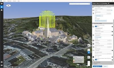
Topcon Positioning Group announces the next generation flight planning system for its rotary-wing aerial UAV offering — Intel Mission Control Software. The new software is designed to facilitate automated flight planning, managing missions, and data handling for the Intel Falcon 8+ Drone – Topcon Edition and its available payload options.

The software is designed to increase accuracy with advanced mapping features that allow operators to easily set project parameters and prepare missions using presets for 2D areas like polygon, corridor and city grid, as well as 3D structures like towers, buildings and facades.

“Operators can take advantage of 2D and 3D map views with the ability to import more precise project details and parameters, including restricted airspace, and support to adapt flight planning over difficult terrain. It features the ability to import elevation, KML, GeoTIFF and Shapefiles for real life visualizations targeted for accurate planning. Plus, expanded preset options support automated flight including circle of interest, panorama, and 2D and 3D missions with automatic elevation and terrain adoption,” said Charles Rihner, vice president of planning for Topcon Emerging Business.

Additionally, the software includes automatic pre-flight safety and system checks while in mission planning. “Operators will receive detailed communication such as estimated battery life, airspace integration, ground and object safety limits, maximum dive and climb rate, minimum and maximum altitude, camera speed, number of images, camera storage, GSD check, and target photo coverage and quality,” said Rihner.

The flight planning software is also designed to improve data handling and export to support easier data processing. “It includes automated image matching and geotagging of images during data import, for increased time saving. Operators can preview and inspect the quality of the collected data, including individual images, as well as an overview of data coverage. Then, they can quickly and easily access and export flight data, and filter datasets for easier processing,” said Rihner.

(Image provided with Topcon news release)

FMI: www.topconpositioning.com

Advertisement

More News

ANN's Daily Aero-Linx (08.27.25)

Aero Linx: The American Society of Aerospace Medicine Specialists (ASAMS) The Society is a non-profit organization created to serve as a voice for and represent the professional ne>[...]

ANN's Daily Aero-Term (08.27.25): Class C Service

Class C Service This service provides, in addition to basic radar service, approved separation between IFR and VFR aircraft, and sequencing of VFR aircraft, and sequencing of VFR a>[...]

ANN FAQ: Submit a News Story!

Have A Story That NEEDS To Be Featured On Aero-News? Here’s How To Submit A Story To Our Team Some of the greatest new stories ANN has ever covered have been submitted by our>[...]

Airborne-NextGen 08.26.25: Iran UAV Knockoffs, X-37B Spaceplane, Army Training

Also: ERAU Uses UAVs, P550 Group 2 UAS, Starship’s Florida Launches, NASA Missions Chopped The Air Force has put out a call to commission a one-to-one copy of the Iranian-des>[...]

Classic Klyde Morris (08.25.25)

Classic Klyde Morris From 11.07.16 (and Remembering Bob...) FMI: www.klydemorris.com>[...]

blog comments powered by Disqus


Advertisement

Advertisement

Podcasts

Advertisement

© 2007 - 2025 Web Development & Design by Pauli Systems, LC