NOAA Finalizes 'Graphic Forecasts For Aviation' | Aero-News Network
Aero-News Network
RSS icon RSS feed
podcast icon MP3 podcast
Subscribe Aero-News e-mail Newsletter Subscribe

Airborne Unlimited -- Most Recent Daily Episodes

Episode Date

Airborne-Monday

Airborne-Tuesday

Airborne-Wednesday Airborne-Thursday

Airborne-Friday

Airborne On YouTube

Airborne-Unlimited-11.24.25

AirborneNextGen-
11.18.25

Airborne-Unlimited-11.19.25

Airborne-AffordableFlyers-11.20.25

AirborneUnlimited-11.21.25

LIVE MOSAIC Town Hall (Archived): www.airborne-live.net

Tue, Apr 18, 2017

NOAA Finalizes 'Graphic Forecasts For Aviation'

Experimental Weather Product Now Operational

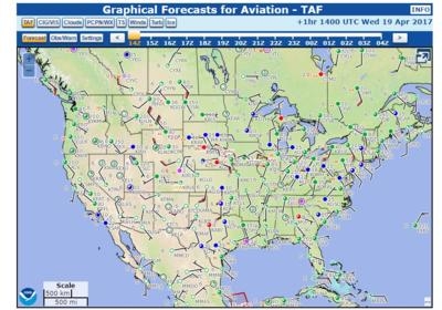
The National Oceanic and Atmospheric Administration (NOAA) has upgraded its experimental "Graphic Forecasts for Aviation" (GFA) to operational status as of Saturday. The new product is accepted by the FAA for weather briefings.

According to NOAA, the Graphical Forecasts for Aviation (GFA) web page is intended to provide the necessary aviation weather information to give users a complete picture of the weather that may impact flight in the continental United States (CONUS). The web page includes observational data, forecasts, and warnings that can be viewed from 14 hours in the past to 15 hours in the future, including thunderstorms, clouds, flight category, precipitation, icing, turbulence and wind. Hourly model data and forecasts, including information on clouds, flight category, precipitation, icing, turbulence, wind, and graphical output from the National Weather Service’s National Digital Forecast Data (NDFD), are available.

Wind, icing and turbulence forecasts are available in 3,000 ft. increments from the surface up to 30,000 ft. MSL, and in 6,000 ft. increments from 30,000 MSL to FL480 (48,000 ft. MSL). Turbulence forecasts are also broken into LO (below 18,000 MSL) and HI (at or above 18,000 MSL) graphics.

A maximum icing graphic and maximum wind velocity graphic (regardless of altitude) are also available. Built with modern geospatial information tools, users can pan and zoom to focus on areas of greatest interest.

The majority of the weather elements contained in the FA are already available through existing NWS products, NOAA says. To maintain continuity of service, the GFA will ensure the availability of equivalent information in addition to adding graphical displays of the predominant weather, sky cover, and wind speed and direction.

(Source: NOAA)

FMI: http://aviationweather.ncep.noaa.gov/gfa
 

Advertisement

More News

NTSB Prelim: Funk B85C

According To The Witness, Once The Airplane Landed, It Continued To Roll In A Relatively Straight Line Until It Impacted A Tree In His Front Yard On November 4, 2025, about 12:45 e>[...]

Aero-News: Quote of the Day (11.21.25)

"In the frame-by-frame photos from the surveillance video, the left engine can be seen rotating upward from the wing, and as it detaches from the wing, a fire ignites that engulfs >[...]

ANN's Daily Aero-Term (11.21.25): Radar Required

Radar Required A term displayed on charts and approach plates and included in FDC NOTAMs to alert pilots that segments of either an instrument approach procedure or a route are not>[...]

Classic Aero-TV: ScaleBirds Seeks P-36 Replica Beta Builders

From 2023 (YouTube Edition): It’s a Small World After All… Founded in 2011 by pilot, aircraft designer and builder, and U.S. Air Force veteran Sam Watrous, Uncasville,>[...]

Airborne 11.21.25: NTSB on UPS Accident, Shutdown Protections, Enstrom Update

Also: UFC Buys Tecnams, Emirates B777-9 Buy, Allegiant Pickets, F-22 And MQ-20 The NTSB's preliminary report on the UPS Flight 2976 crash has focused on the left engine pylon's sep>[...]

blog comments powered by Disqus


Advertisement

Advertisement

Podcasts

Advertisement

© 2007 - 2025 Web Development & Design by Pauli Systems, LC