FAA Places TFR Around Kobe Bryant Accident Site | Aero-News Network
Aero-News Network
RSS icon RSS feed
podcast icon MP3 podcast
Subscribe Aero-News e-mail Newsletter Subscribe

Airborne Unlimited -- Most Recent Daily Episodes

Episode Date

Airborne-Monday

Airborne-Tuesday

Airborne-Wednesday Airborne-Thursday

Airborne-Friday

Airborne On YouTube

Airborne-Unlimited-05.05.25

Airborne-NextGen-05.06.25

AirborneUnlimited-05.07.25

Airborne-Unlimited-05.01.25

AirborneUnlimited-05.02.25

Thu, Jan 30, 2020

FAA Places TFR Around Kobe Bryant Accident Site

Prompted In Part By A Large Number Of Drones Flying Over The Area

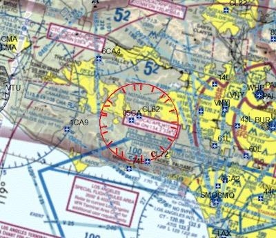
The FAA issued a NOTAM late Sunday night that placed a TFR over the site where the helicopter carrying former NBA star Kobe Bryant, his 13-year-old daughter, and seven others on board went down, largely due to a large number of drones flying over the site.

All on board the helicopter were fatally injured in the accident, which occurred Sunday morning.

The TFR, which is in place through January 31, includes airspace five nautical miles in all directions from the accident site up to an altitude of 5,000 feet MSL.

The NOTAM was issued "provide a safe environment for accident investigation," according to the document posted online by the FAA.

DroneDJ reports that, according to Business Insider, an FAA spokesperson said that there were a "significant number of aircraft, including drones, operating over the accident site."

CNN reports that the NTSB wrapped up recovery operations on Tuesday at the accident scene. According to investigators, the aircraft was a 2,300 feet AGL when communications with the aircraft were lost. The pilot said he was climbing to avoid a cloud layer. NTSB Board Member Jennifer Homendy said that the aircraft appears to have been intact when it impacted terrain, and it was not equipped with a TAWS to provide information about terrain.

Homendy said the helicopter missed clearing the mountain by 20-30 feet.

FMI: NOTAM
DroneDJ
CNN

Advertisement

More News

ANN's Daily Aero-Term (05.05.25): Circle To Runway (Runway Number)

Circle To Runway (Runway Number) Used by ATC to inform the pilot that he/she must circle to land because the runway in use is other than the runway aligned with the instrument appr>[...]

ANN's Daily Aero-Linx (05.05.25)

Aero Linx: National Aviation Safety Foundation (NASF) The National Aviation Safety Foundation is a support group whose objective is to enhance aviation safety through educational p>[...]

NTSB Prelim: De Havilland DHC-1

At Altitude Of About 250-300 Ft Agl, The Airplane Experienced A Total Loss Of Engine Power On November 6, 2024, at 1600 central standard time, a De Havilland DHC-1, N420TD, was inv>[...]

Classic Aero-TV: The Boeing Dreamliner -- Historic First Flight Coverage

From 2009 (YouTube Edition): Three Hour Flight Was 'Flawless' -- At Least, Until Mother Nature Intervened For anyone who loves the aviation business, this was a VERY good day. Afte>[...]

Airborne-NextGen 05.06.25: AF Uncrewed Fighters, Drones v Planes, Joby Crew Test

Also: AMA Names Tyler Dobbs, More Falcon 9 Ops, Firefly Launch Unsuccessful, Autonomous F-16s The Air Force has begun ground testing a future uncrewed jet design in a milestone tow>[...]

blog comments powered by Disqus


Advertisement

Advertisement

Podcasts

Advertisement

© 2007 - 2025 Web Development & Design by Pauli Systems, LC