Thu, Dec 06, 2007
 NOTAM Number: FDC 7/6349
Issue Date: December 05, 2007 at 0017 UTC
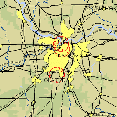
Location: Kansas City, Missouri
Beginning Date and Time: December 07, 2007 at 1625 UTC
Ending Date and Time: December 07, 2007 at 2040 UTC
Reason for NOTAM: Temporary flight restrictions for VIP (Very
Important Person) Movement
Type: VIP
Replaced NOTAM(s): N/A
Affected Area(s)
Area A
Airspace Definition:
Center: 0.3 nautical miles from RIVERSIDE VOR/DME(RIS) on
the 103 radial (Latitude: 39º07'08"N, Longitude:
94º35'26"W)
Radius: 3 nautical miles
Altitude: From the surface up to but not including 3000 feet
AGL
Effective Date(s):
From December 07, 2007 at 1625 UTC (December 07, 2007 at 1025
CST)
To December 07, 2007 at 1715 UTC (December 07, 2007 at 1115
CST)
Area B
Airspace Definition:
Center: 6.9 nautical miles from JOHNSON COUNTY VOR/DME(OJC)
on the 041 radial (Latitude: 38º55'06"N, Longitude:
94º37'43"W)
Radius: 3 nautical miles
Altitude: From the surface up to but not including 3000 feet
AGL
Effective Date(s):
From December 07, 2007 at 1705 UTC (December 07, 2007 at 1105
CST)
To December 07, 2007 at 1910 UTC (December 07, 2007 at 1310
CST)
Area C
Airspace Definition:
Center: 2.3 nautical miles from RIVERSIDE VOR/DME(RIS) on the
160 radial (Latitude: 39º04'58"N, Longitude:
94º35'00"W)
Radius: 3 nautical miles
Altitude: From the surface up to but not including 3000 feet
AGL
Effective Date(s):
From December 07, 2007 at 1900 UTC (December 07, 2007 at 1300
CST)
To December 07, 2007 at 2020 UTC (December 07, 2007 at 1420
CST)
Area D
Airspace Definition:
Center: 0.3 nautical miles from RIVERSIDE VOR/DME(RIS) on the
103 radial (Latitude: 39º07'08"N, Longitude:
94º35'26"W)
Radius: 3 nautical miles
Altitude: From the surface up to but not including 3000 feet
AGL
Effective Date(s):
From December 07, 2007 at 1950 UTC (December 07, 2007 at 1350
CST)
To December 07, 2007 at 2040 UTC (December 07, 2007 at 1440
CST)
Operating Restrictions and Requirements
No pilots may operate an aircraft in the areas covered by this
NOTAM (except as described).
Unless otherwise authorized by ATC.
Other Information:
ARTCC: ZKC - Kansas City Center
Authority: Title 14 CFR section 91.141
FMI: www.tfr.faa.gov,
Depicted TFR data may not be a complete listing. Pilots should not
use the information on this website for flight planning purposes.
For the latest information, call your local Flight Service Station
at 1-800-WX-BRIEF.
More News
Circle To Runway (Runway Number) Used by ATC to inform the pilot that he/she must circle to land because the runway in use is other than the runway aligned with the instrument appr>[...]
Aero Linx: National Aviation Safety Foundation (NASF) The National Aviation Safety Foundation is a support group whose objective is to enhance aviation safety through educational p>[...]
At Altitude Of About 250-300 Ft Agl, The Airplane Experienced A Total Loss Of Engine Power On November 6, 2024, at 1600 central standard time, a De Havilland DHC-1, N420TD, was inv>[...]
From 2009 (YouTube Edition): Three Hour Flight Was 'Flawless' -- At Least, Until Mother Nature Intervened For anyone who loves the aviation business, this was a VERY good day. Afte>[...]
Also: AMA Names Tyler Dobbs, More Falcon 9 Ops, Firefly Launch Unsuccessful, Autonomous F-16s The Air Force has begun ground testing a future uncrewed jet design in a milestone tow>[...]
 ANN's Daily Aero-Term (05.05.25): Circle To Runway (Runway Number)

