New Drone Surveillance System to be Deployed on Canadian Coast Guard Vessels | Aero-News Network
Aero-News Network
RSS icon RSS feed
podcast icon MP3 podcast
Subscribe Aero-News e-mail Newsletter Subscribe

Airborne Unlimited -- Most Recent Daily Episodes

Episode Date

Airborne-Monday

Airborne-Tuesday

Airborne-Wednesday Airborne-Thursday

Airborne-Friday

Airborne On YouTube

Airborne-Unlimited-07.14.25

Airborne-NextGen-07.15.25

AirborneUnlimited-07.16.25

Airborne-FlightTraining-07.17.25

AirborneUnlimited-07.11.25

Tue, Feb 16, 2021

New Drone Surveillance System to be Deployed on Canadian Coast Guard Vessels

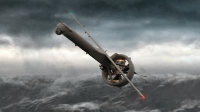
V-BAT UAS Is A Fixed-Wing VTOL Aircraft

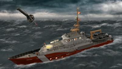
Kongsberg Geospatial has been selected by Defence Research and Development Canada (DRDC) to conduct trials of a new long-endurance UAV surveillance system for the Canadian Coast Guard. The MartinUAV V-BAT aircraft was selected to provide the ability to combine take off and landing from the small confines aboard ship with the long endurance of a fixed-wing aircraft while carrying multiple sensors.

The aircraft will communicate with the Kongsberg Geospatial sensor data management system, called MIDAS, which allows a range of sensor data, including full-motion video from unmanned systems to be processed and exploited in near real-time by analysts on board Canadian Coast Guard ships. MIDAS provides the capability to compare historical and live data from the mission area, and to examine sensor data with a variety of tools, including motion and object detection, in near-real time. This near real-time analytical capability can greatly enhance the effectiveness of UAVs for a variety of mission types.

The V-BAT UAS provided by Martin UAV is a fixed-wing VTOL aircraft specifically designed to operate from very small spaces on ships, land, and nearly any environment. The V-BAT is a long-endurance aircraft capable of carrying multiple sensors, including land and maritime wide area surveillance.

Kongsberg Geospatial’s MIDAS is derived from technologies created for the NATO Alliance Ground Surveillance project which required the storage and retrieval of vast amounts of intelligence data for Intelligence Analysts. The system directly addresses the problem that the vast majority of UAVs have no standards-compliant capability to process, exploit, and distribute (PED) their sensor data where it is being used. MIDAS provides a fully standards-compliant system that allows intelligence analysts to view, process, and analyze sensor data in near real-time, from where the drone is being operated. MIDAS has packaged these capabilities into a tactical and portable form factor to enables those surveillance capabilities to be deployed as a portable system on board a ship, or in a temporary command post.

CINTIQS Military Technology Consulting will be providing consulting services for the planning and conduct of the flight trials and sensor employment to validate systems performance.

The combination of the Martin UAV V-BAT and the Kongsberg MIDAS sensor data management system will allow Coast Guard vessels to expand their surveillance range for search and rescue missions, and for the surveillance of the movement of icebergs, without requiring the use of manned aircraft.

“UAVs are a useful tool, but they only truly effective if they can collect sensor data that results in actionable intelligence,” said Ranald McGillis, President of Kongsberg Geospatial. “Our MIDAS system allows users to fully exploit raw sensor data, and derive useful intelligence at the tactical edge where the UAV is being used. In a search and rescue context, that could mean using infrared sensors, or near real-time motion detection to locate a subject when visibility or weather conditions are poor.”

FMI: https://kongsberggeospatial.com, http://martinuav.com, https://cintiqs.com, www.ccg-gcc.gc.ca/index-eng.html

Advertisement

More News

ANN's Daily Aero-Term (07.15.25): Charted Visual Flight Procedure Approach

Charted Visual Flight Procedure Approach An approach conducted while operating on an instrument flight rules (IFR) flight plan which authorizes the pilot of an aircraft to proceed >[...]

Aero-News: Quote of the Day (07.15.25)

“When l became the Secretary of Defense, I committed to rebuild our military to match threats to capabilities. Drones are the biggest battlefield innovation in a generation, >[...]

ANN's Daily Aero-Linx (07.15.25)

Aero Linx: Stearman Restorers Association Welcome to the Stearman Restorers Association. The Stearman Restorers Association is an independent “Not for Profit” 501C-3 Co>[...]

NTSB Final Report: Kjelsrud Gary Kitfox

Airplane Exhibited A Partial Loss Of Engine Power When It Was About Halfway Down The Runway Analysis: The pilot of the experimental amateur-built airplane was departing from his pr>[...]

NTSB Prelim: Cessna A150L

The Flight Path Was Consistent With Low-Altitude Maneuvering On June 18, 2025, about 0922 mountain standard time, a Cessna A150L airplane, N6436F, was substantially damaged when it>[...]

blog comments powered by Disqus


Advertisement

Advertisement

Podcasts

Advertisement

© 2007 - 2025 Web Development & Design by Pauli Systems, LC