SenseFly & Trimble Optimize Workflow For Geospatial Drone Operators | Aero-News Network
Aero-News Network
RSS icon RSS feed
podcast icon MP3 podcast
Subscribe Aero-News e-mail Newsletter Subscribe

Airborne Unlimited -- Most Recent Daily Episodes

Episode Date

Airborne-Monday

Airborne-Tuesday

Airborne-Wednesday Airborne-Thursday

Airborne-Friday

Airborne On YouTube

Airborne-Unlimited-06.23.25

Airborne-NextGen-06.24.25

AirborneUnlimited-06.25.25

Airborne-AffordableFlyers-06.26.25

AirborneUnlimited-06.27.25

Mon, Apr 09, 2018

SenseFly & Trimble Optimize Workflow For Geospatial Drone Operators

New Collaboration Ensures Seamless Integration Between SenseFly’s Emotion Flight & Data Management Software And Trimble Business Center Aerial Photogrammetry Module

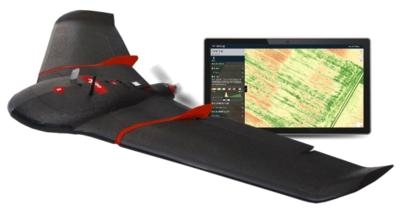
Professional drone solution provider senseFly has announced a new software integration with Trimble, which optimizes the drone mapping workflow for geospatial professionals.

The new integration between the company’s software ensures the smoothest possible end-to-end mapping drone (UAS) workflow. senseFly operators can now, within their drone’s recently launched eMotion 3.5 software, transform a senseFly S.O.D.A. camera’s georeferenced imagery into an automatically-collated project (in .jxl format). This enables the simple, one-click import of drone imagery into the Trimble Business Center Aerial Photogrammetry module without the need for manual project creation and organization of images.

The senseFly-to-Trimble mapping workflow becomes as simple as:

  • Planning & monitoring a senseFly S.O.D.A.-based drone flight (in eMotion 3.5)
  • Downloading the drone’s images for one-click georeferencing in eMotion 3.5 (Flight Data Manager)
  • Clicking to create a .jxl format mapping project
  • Opening a project within the Trimble Business Center Aerial Photogrammetry module
  • Processing the drone’s imagery to generate orthophotos, contour maps, point clouds, digital surface models (DSMs) & feature maps Analyzing & acting upon the data

“Making work easier and more efficient for geospatial professionals is the goal that drives every solution we develop,” said Jean-Christophe Zufferey, senseFly’s Co-Founder and CEO. “Therefore, we are excited to collaborate with Trimble on more tightly integrating our solutions, since enhancements such as this new eMotion-to-Trimble Business Center workflow do exactly that, ensuring that the transition from data collection to acting upon this data is as seamless as possible.”

The senseFly S.O.D.A. is the first camera to be built for professional drone photogrammetry work. This 1-inch, 20-megapixel RGB camera captures amazingly sharp aerial images, across a range of light conditions, allowing senseFly fixed-wing drone operators to produce detailed, vivid orthomosaics and ultra-accurate 3D digital surface models. senseFly S.O.D.A. is compatible with most senseFly fixed-wing mapping drones, including the large-coverage eBee Plus.

In addition to producing powerful photogrammetric deliverables, Trimble Business Center allows surveyors and other geospatial professionals to combine aerial photography with data collected from GNSS receivers, total stations, 3D laser scanners and more, for a complete field-to-finish workflow. By easily combining imagery from unmanned aerial systems with ground-based survey data, users can visualize their project from both aerial and terrestrial perspectives, measure points within the images and create 3D models of the infrastructure and terrain.

(Source: senseFly news release. Images from file)

FMI: www.parrot.com

Advertisement

More News

NTSB Final Report: Rutan Long-EZ

He Attempted To Restart The Engine Three Times. On The Third Restart Attempt, He Noticed That Flames Were Coming Out From The Right Wing Near The Fuel Cap Analysis: The pilot repor>[...]

ANN FAQ: Turn On Post Notifications

Make Sure You NEVER Miss A New Story From Aero-News Network Do you ever feel like you never see posts from a certain person or page on Facebook or Instagram? Here’s how you c>[...]

Classic Aero-TV: ICAS Perspectives - Advice for New Air Show Performers

From 2009 (YouTube Edition): Leading Air Show Performers Give Their Best Advice for Newcomers On December 6th through December 9th, the Paris Las Vegas Hotel hosted over 1,500 air >[...]

ANN's Daily Aero-Linx (06.28.25)

Aero Linx: NASA ASRS ASRS captures confidential reports, analyzes the resulting aviation safety data, and disseminates vital information to the aviation community. The ASRS is an i>[...]

Aero-News: Quote of the Day (06.28.25)

“For our inaugural Pylon Racing Seminar in Roswell, we were thrilled to certify 60 pilots across our six closed-course pylon race classes. Not only did this year’s PRS >[...]

blog comments powered by Disqus


Advertisement

Advertisement

Podcasts

Advertisement

© 2007 - 2025 Web Development & Design by Pauli Systems, LC