Memorial To UTA Flight 772 Visible On Google Earth | Aero-News Network
Aero-News Network
RSS icon RSS feed
podcast icon MP3 podcast
Subscribe Aero-News e-mail Newsletter Subscribe

Airborne Unlimited -- Most Recent Daily Episodes

Episode Date

Airborne-Monday

Airborne-Tuesday

Airborne-Wednesday Airborne-Thursday

Airborne-Friday

Airborne On YouTube

Airborne-Unlimited-11.03.25

AirborneNextGen-
11.04.25

Airborne-Unlimited-11.05.25

Airborne-Unlimited-11.06.25

AirborneUnlimited-10.17.25

Affordable Flying Expo Tickets (Discount Code: AFE2025): CLICK HERE!
LIVE MOSAIC Town Hall, 1800ET, 11.07.25: www.airborne-live.net

Wed, Nov 06, 2013

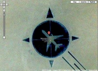
Memorial To UTA Flight 772 Visible On Google Earth

Plane Downed By Libyan Terrorists With A Bomb In The Sahara Desert

On September 19, 1989, Libyan Terrorists planted a briefcase bomb aboard UTA Flight 772 traveling from Brazzavile in the Republic of Congo to Chad and then on to Paris. The bomb detonated over the Sahara Desert, destroying the DC-10 and killing all 170 people on board.

A memorial to those lost on the flight was created in 2007, but given it's desolate location, let's just say it's not a major tourist attraction.

But that doesn't mean you can’t see the memorial, thanks to the magic that is the Internet and Google Earth or Google Maps. A story appearing on The Blaze reports that by typing in 16°51'53"N, 11°57'13"E and zooming down to near ground level, an image of the outline of a DC10 in a compass rose indicating the airplane's route of flight appears.

The memorial is composed mostly of black rocks carefully arranged in the shape of the compass rose, with the desert sand showing through in the outline of the airplane.

Six Libyans were eventually convicted of planting the bomb that brought down the airplane.

(Image from Google Maps)

FMI: http://www.viralnova.com/i-noticed-this-tiny-thing-on-google-maps-and-when-i-zoomed-in-well-nothing-could-prepare-me/

Advertisement

More News

Airborne-NextGen 11.04.25: Anduril YFQ-44A, Merlin SOI 2, UAV Rulemaking Stalled

Also: Horizon Picks P&W PT6A, Army Buys 3 EagleNXT, First Hybrid-Electric Regional, Army Selects AEVEX Anduril Industries’ YFQ-44A Collaborative Combat Aircraft was flown>[...]

NTSB Prelim: Elmore Travis C Searey

While Flying North Along The Beach At About 300 Ft Above Ground Level, The Pilot Reported That The Engine RPM Dropped To About Idle On September 28, 2025, at 1126 eastern daylight >[...]

ANN's Daily Aero-Linx (11.03.25)

Aero Linx: European Association of Aviation Training and Educational Organisations (EATEO) Welcome to the “ European Association of Aviation Training and Education Organizati>[...]

ANN's Daily Aero-Term (11.03.25): On-Course Indication

On-Course Indication An indication on an instrument, which provides the pilot a visual means of determining that the aircraft is located on the centerline of a given navigational t>[...]

Aero-News: Quote of the Day (11.03.25)

“It also gives us the hard data we need to shape requirements, reduce risk, and ensure the CCA program delivers combat capability on a pace and scale that keeps us ahead of t>[...]

blog comments powered by Disqus


Advertisement

Advertisement

Podcasts

Advertisement

© 2007 - 2025 Web Development & Design by Pauli Systems, LC