ForeFlight’s MORA/LSALT Overlays: Better Enroute Terrain Clearance | Aero-News Network
Aero-News Network
RSS icon RSS feed
podcast icon MP3 podcast
Subscribe Aero-News e-mail Newsletter Subscribe

Airborne Unlimited -- Most Recent Daily Episodes

Episode Date

Airborne-Monday

Airborne-Tuesday

Airborne-Wednesday Airborne-Thursday

Airborne-Friday

Airborne On YouTube

Airborne-Unlimited-06.23.25

Airborne-NextGen-06.24.25

AirborneUnlimited-06.25.25

Airborne-AffordableFlyers-06.26.25

AirborneUnlimited-06.27.25

Sun, Apr 14, 2024

ForeFlight’s MORA/LSALT Overlays: Better Enroute Terrain Clearance

Grid Overlay Is A Feature That Promises To Improve Enroute Terrain Clearance For Pilots

The aviation industry continually seeks advancements in technology to enhance flight safety and pilot confidence. One of the latest innovations in this field is the introduction of ForeFlight’s MORA/LSALT MORA, or Minimum Off-Route Altitude, and LSALT, the Lowest Safe Altitude in Australia, are essential metrics for pilots to maintain safe clearance from terrain and obstacles when deviating from a planned route.

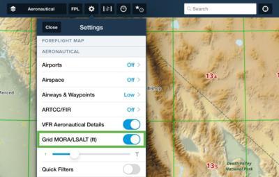
ForeFlight's new overlay feature integrates these altitudes directly onto the Aeronautical Map, providing a visual aid that is invaluable for flight planning and in-flight navigation. The overlay displays altitudes in feet, with the first number indicating thousands and the second, smaller number indicating hundreds within the grid. This design allows pilots to quickly ascertain the minimum safe altitudes required for their flight path.

As pilots zoom in on the map, the grid dynamically adjusts from a 5°x5° to a 1°x1° scale, offering more granular information.

A key aspect of the Grid MORA overlay is its color-coding system. Altitudes below 10,000 feet are shown in green, signaling lower terrain or obstacle heights, while altitudes above 10,000 feet are marked in red, denoting higher terrain or obstacles. This immediate visual distinction aids pilots in making quick, informed decisions about their altitude, especially in unfamiliar or challenging environments.

The Grid MORA also includes altitude buffers of 1,000 feet for altitudes of 6,000 feet or less and a 2,000 feet buffer for altitudes above 7,000 feet. These buffers provide a global standard for obstacle clearance, differing from the U.S.-specific OROCA, which uses a uniform 1,000-foot buffer except in designated mountainous regions where it increases to 2,000 feet.

ForeFlight’s dedication to pilot safety is further demonstrated by additional features such as Aircraft on Same Runway Alerts and Controlled Airspace Alerts, which now include RMZs (Radio Mandatory Zones) and their frequencies. These alerts offer critical safety information and convenient reference points for pilots navigating controlled airspace. The MORA/LSALT Grid Overlay is enabled by default but can be turned off in the Map Settings for those who prefer a traditional view. This flexibility ensures that ForeFlight?s application meets the diverse needs of the aviation community.

By providing pilots with an intuitive, visual representation of safe altitudes, ForeFlight enhances pilot confidence and contributes to safer skies. Tools like the MORA/LSALT Grid Overlay will undoubtedly become indispensable in a pilot’s tool set.

FMI:www.foreflight.com

Advertisement

More News

NTSB Final Report: Rutan Long-EZ

He Attempted To Restart The Engine Three Times. On The Third Restart Attempt, He Noticed That Flames Were Coming Out From The Right Wing Near The Fuel Cap Analysis: The pilot repor>[...]

ANN FAQ: Turn On Post Notifications

Make Sure You NEVER Miss A New Story From Aero-News Network Do you ever feel like you never see posts from a certain person or page on Facebook or Instagram? Here’s how you c>[...]

Classic Aero-TV: ICAS Perspectives - Advice for New Air Show Performers

From 2009 (YouTube Edition): Leading Air Show Performers Give Their Best Advice for Newcomers On December 6th through December 9th, the Paris Las Vegas Hotel hosted over 1,500 air >[...]

ANN's Daily Aero-Linx (06.28.25)

Aero Linx: NASA ASRS ASRS captures confidential reports, analyzes the resulting aviation safety data, and disseminates vital information to the aviation community. The ASRS is an i>[...]

Aero-News: Quote of the Day (06.28.25)

“For our inaugural Pylon Racing Seminar in Roswell, we were thrilled to certify 60 pilots across our six closed-course pylon race classes. Not only did this year’s PRS >[...]

blog comments powered by Disqus


Advertisement

Advertisement

Podcasts

Advertisement

© 2007 - 2025 Web Development & Design by Pauli Systems, LC