Sun, Nov 14, 2010
Area, Enroute Charts For North America With Automatic
Updates
Jeppesen has rolled out subscription services for its U.S.
VFR+GPS charts, available on an annual renewal basis. VFR pilots in
North America are now able to automatically receive updated Area
and Enroute charts, rather than purchase charts per each revision
cycle.

“The introduction of one-year subscription services for
Jeppesen VFR+GPS charts is an exciting development for our VFR
customers, as they are able to now enjoy the convenience of
automated delivery of the industry’s most accurate and
complete VFR+GPS charts, without having to remember to track down
the latest revision,” said Tim Huegel, director, Jeppesen
Portfolio Management, announcing the service Thursday. “As an
added benefit, Jeppesen VFR+GPS annual chart subscribers also will
receive a pricing discount versus the regular retail
pricing.”
Jeppesen U.S. VFR+GPS charts integrate FAA aeronautical
information with state-of-the-art cultural, obstacle and terrain
data, which deliver a new breed of VFR chart that complements
modern GPS technology and devices. Intuitive symbols and
contrasting colors allow for at-a-glance orientation and improved
situational awareness. Controlled airspace types and sectors are
depicted with clear, crisp lines with intuitive airspace type and
altitude labels on each boundary. Regardless of airspace type,
proximity or complexity, a quick chart glance alerts pilots to what
airspace they are in or near.
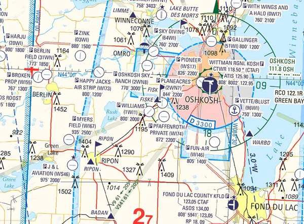
Jeppesen VFR+GPS Chart
Available in two scales, the 1:250,000 Area chart is a high
detail depiction of Class B airspace and the surrounding area. The
1:500,000 Enroute chart is oriented around actual VFR flight
activity and covers areas that pilots typically fly – in many
cases, resulting in fewer charts needed for flight.
VFR+GPS chart subscriptions are available for Jeppesen customers
per individual chart used. Similar to Jeppesen IFR subscriptions,
each VFR+GPS chart requires a separate chart subscription. Future
plans call for development of “regions,” where
subscription coverage would include a collection of Area and
Enroute charts.
More News
He Attempted To Restart The Engine Three Times. On The Third Restart Attempt, He Noticed That Flames Were Coming Out From The Right Wing Near The Fuel Cap Analysis: The pilot repor>[...]
Make Sure You NEVER Miss A New Story From Aero-News Network Do you ever feel like you never see posts from a certain person or page on Facebook or Instagram? Here’s how you c>[...]
From 2009 (YouTube Edition): Leading Air Show Performers Give Their Best Advice for Newcomers On December 6th through December 9th, the Paris Las Vegas Hotel hosted over 1,500 air >[...]
Aero Linx: NASA ASRS ASRS captures confidential reports, analyzes the resulting aviation safety data, and disseminates vital information to the aviation community. The ASRS is an i>[...]
“For our inaugural Pylon Racing Seminar in Roswell, we were thrilled to certify 60 pilots across our six closed-course pylon race classes. Not only did this year’s PRS >[...]
 NTSB Final Report: Rutan Long-EZ

