Airplane Reportedly Broke Up In Flight During Instruction, Three Fatally Injured
The NTSB has released a preliminary report from an accident involving a Cessna 172 on a training flight in Washington State that resulted in the fatal injury of the three people on board the aircraft.
According to the report, on July 13, 2018, at 1021 Pacific daylight time, a Cessna 172R Skyhawk airplane, N24442, experienced an inflight breakup and collided into a field near Deer Park, Washington. The certified flight instructor (CFI) and two student pilots were fatally injured. The airplane was substantially damaged. The airplane was registered to, and operated by, Moody Bible Institute of Chicago under the provisions of Title 14 Code of Federal Regulations Part 141. Visual meteorological conditions prevailed at the time of the accident and no flight plan had been filed; the pilot was receiving flight following advisories. The local training flight originated from Felts Field Airport, Spokane, Washington about 0955.
The purpose of the flight was for the front-seated student pilot to undergo instruction. This was the first flight in his training program and the aft-seated student pilot was an observer. Following departure, the CFI communicated with the Spokane Terminal Radar Approach Control (GEG TRACON) and proceeded to the Clayton practice area located about 15 miles northwest of the airport. When another student and instructor were looking for the airplane to use for their scheduled flight, the operator noticed the airplane was late. About 1110 the operator attempted to communicate with the CFI on the radio and on his cell phone. Thereafter, the operator contacted the TRACON and eventually they confirmed that the airplane had gone missing from their radar about 1021.
A review of the preliminary track data indicated that after entering Clayton, at 1010 the airplane began a gradual 90° left-turn and continued in a southwestern direction. The airplane continued in a gradual climb to about 7,000 ft mean sea level (msl) and then made a 180° right turn. The flight track remained on a northeastern heading until about 1018, at which point the airplane made another 180° turn to the heading of 208°. The airplane proceeded about 2.5 miles varying in altitude between from about 7,000 to 7,450 ft msl. At 1020:53 the track data indicated the airplane at an altitude of 7,000 ft msl and an estimated ground speed of 77 knots. From that point, the track made a sharp 90° right-turn and continued on a 305° heading for about 3,020 ft over a duration of about 20 seconds. The track then made another sharp 90° right-turn and after about 880 ft and the last recorded track data at 1021:18 indicated an estimated ground speed of 117 knots. The accident site was
located about 740 ft southwest of the last recorded track data.
Witnesses reported that the airplane was in a steep dive toward terrain and then they subsequently observed the wings departing the airplane at the same time.
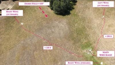
The accident site was located in a grass field in the rural farm land of Deer Park about 20 nautical miles northwest of Felts Field. In character, the open fields are surrounded by densely populated tree stands. The elevation of the main wreckage was 2,265 ft msl.
The wreckage was distributed over a 400 ft distance on a median magnetic bearing of about 030°. The outboard sections of both the right and left wing were located at the beginning of the debris field about 330 and 190 ft from the main wreckage, respectively (see below Figure 1). The debris between the outboard wing sections and the main wreckage consisted of left wing pieces. All control surfaces and their associated mass balance weights were accounted for in the debris field.
(Image provided with NTSB preliminary report)
 ANN's Daily Aero-Term (12.01.25): Convective SIGMET

