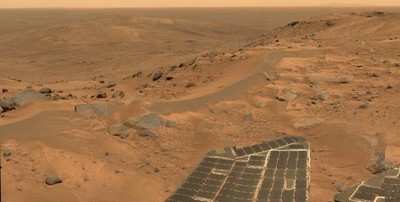
The View From Husband Hill
Working atop a range of Martian hills, NASA's Spirit rover is
rewarding researchers with tempting scenes filled with evidence of
past planet environments.
"When the images came down and we could see horizon all the way
around, that was every bit as exhilarating as getting to the top of
any mountain I've climbed on Earth," said Chris Leger, a rover
planner at NASA's Jet Propulsion Laboratory (JPL), Pasadena,
Calif.
The summit sits 82 meters (269 feet) above the edge of the
surrounding plains. It is 106 meters (348 feet) higher than the
site where Spirit landed nearly 20 months ago. Spirit and twin
rover, Opportunity, successfully completed their three-month prime
missions in April 2004. They have inspected dozens of rocks and
soil targets since then, continuing their pursuit of geological
evidence about formerly wet conditions on Mars.
"Spirit has climbed to the hilltop and looked over the other
side, but NASA did not do this just to say we can do it. The Mars
rovers are addressing fundamental questions about Martian history
and planetary environments," said NASA's Mars Exploration Program
Director Doug McCuistion.
The crest of "Husband Hill" offers Spirit's views of possible
routes into a basin to the south with apparently layered outcrops.
Shortly after Spirit landed, it observed a cluster of seven hills
about 3 kilometers (2 miles) east of its landing site. NASA
proposed naming the range "Columbia Hills" in tribute to the last
crew of Space Shuttle Columbia. The tallest of the hills
commemorates Rick Husband, Columbia's commander.
Volcanic rocks covering the plain Spirit crossed on its way to
the hills bore evidence of only slight alteration by water. When
Spirit reached the base of the hills five months after landing, it
immediately began finding rocks with wetter histories.
"This climb was motivated by science," said Steve Squyres of
Cornell University, Ithaca, N.Y. Squyres is principal investigator
for the rovers' science instruments. "Every time Spirit has gained
altitude, we've found different rock types. Also, we're doing what
any field geologist would do in an area like this: climbing to a
good vantage point for plotting a route," he added. Researchers are
viewing possible routes south to apparently layered ledges and to a
feature dubbed "home plate," which might be a plateau of older rock
or a filled-in crater.
The landing site and the Columbia Hills are within Gusev Crater,
a bowl about 150 kilometers (95 miles) in diameter. It was selected
for the Spirit mission because the shape of the terrain suggests
the crater once held a lake. Volcanic deposits appear to have
covered any sign of ancient lakebed geology out on the plain, but
scientists say the hills expose older layers that have been lifted
and tipped by a meteorite impact or other event.

"We're finding abundant evidence for alteration of rocks in a
water environment," said Ray Arvidson of Washington University, St.
Louis, Mo. Arvidson is deputy principal investigator for the
rovers' science instruments. "What we want to do is figure out
which layers were on top of which other layers. To do that it has
been helpful to keep climbing for good views of how the layers are
tilted to varying degrees. Understanding the sequence of layers is
equivalent to having a deep drill core from drilling beneath the
plains," he added.
Both Spirit and Opportunity have been extremely successful.
Their solar panels are generating plenty of energy thanks to
repeated dust-cleaning events. Spirit has driven 4,827 meters (3.00
miles), and Opportunity 5,737 meters (3.56 miles).
JPL manages the Mars Exploration Rover project for NASA's
Science Mission Directorate.
 ANN's Daily Aero-Linx (04.30.25)