Garmin Pilot for Android Adds Interactive Map Features | Aero-News Network
Aero-News Network
RSS icon RSS feed
podcast icon MP3 podcast
Subscribe Aero-News e-mail Newsletter Subscribe

Airborne Unlimited -- Most Recent Daily Episodes

Episode Date

Airborne-Monday

Airborne-Tuesday

Airborne-Wednesday Airborne-Thursday

Airborne-Friday

Airborne On YouTube

Airborne-Unlimited-07.07.25

Airborne-NextGen-07.08.25

AirborneUnlimited-07.09.25

Airborne-FlightTraining-07.10.25

AirborneUnlimited-07.11.25

Sat, Apr 19, 2014

Garmin Pilot for Android Adds Interactive Map Features

Latest Update Includes Track-Up Orientation

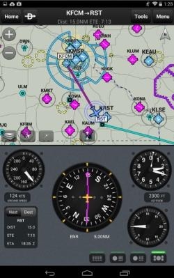
The latest update to the Garmin Pilot app for Android adds new interactive features that make it easier for pilots to navigate and read charts throughout their flight. New features include track-up orientation, faster map rendering, higher resolution at tighter zoom levels and SafeTaxi integration on the moving map display.

Track-Up Version 3.0 of Garmin Pilot for Android offers pilots the option to select track-up orientation on static sectionals and enroute charts so information is always upright and displayed in the direction of flight. With traditional static maps, labels appear in a fixed orientation, so when the map is rotated labels may appear sideways or upside down. Garmin’s detailed, interactive maps smoothly turn text and labels such as airspace, obstacle notations and important frequencies so they are always upright and easy to read.

Highly configurable interactive maps enable pilots to customize the moving map display on Garmin Pilot. Map color, visibility range, label sizes for airports, NAVAIDs and more, may be tailored to pilot preference so important information pertaining to each flight is always in view. Faster map rendering and the ability to zoom in tighter allows pilots to easily view frequency information, chart and obstacle text, ensuring nothing is overlooked throughout each flight.

Simply panning in over an airport on the moving map page populates the airport diagram, providing pilots with easy access to taxiway and runway information. When taxiing on the airport surface, SafeTaxi conveniently geo-references the aircraft’s position on the diagram, adding to situational awareness at unfamiliar airports. Customers looking to incorporate SafeTaxi may do so with a paid subscription.

In addition to configurable maps and SafeTaxi diagrams within Garmin Pilot, the app update also includes the following new features:

  • Range rings
  • Extended runway centerlines
  • Distance measuring tool

The latest Android update offers a consistent experience across the entire Garmin product line. Pilots will notice a similar interface on Garmin Pilot and will feel comfortable transitioning between our certified products and the app. The latest version of Garmin Pilot is available immediately as a free update to existing Android customers.

For new customers, the latest version of Garmin Pilot is available in the Google Play store as a free download for the first 30 days. After the 30-day trial period, pilots may upgrade to a subscription that fits their flying needs.

(Image provided by Garmin)

FMI: www.garmin.com

Advertisement

More News

Aero-News: Quote of the Day (07.11.25)

“Honored to accept this mission. Time to take over space. Let’s launch.” Source: SecTrans Sean Duffy commenting after President Donald Trump appointed U.S. Secret>[...]

ANN's Daily Aero-Term (07.11.25): Permanent Echo

Permanent Echo Radar signals reflected from fixed objects on the earth's surface; e.g., buildings, towers, terrain. Permanent echoes are distinguished from “ground clutter&rd>[...]

ANN's Daily Aero-Linx (07.11.25)

Aero Linx: European Hang Gliding and Paragliding Union (EHPU) The general aim of the EHPU is to promote and protect hang gliding and paragliding in Europe. In order to achieve this>[...]

NTSB Final Report: Schweizer SGS 2-33A

Glider Encountered A Loss Of Lift And There Was Not Sufficient Altitude To Reach The Airport Analysis: The flight instructor reported that while turning final, the glider encounter>[...]

NTSB Prelim: Aeronca 7AC

Airplane Climbed To 100 Ft Above Ground Level, At Which Time The Airplane Experienced A Total Loss Of Engine Power On May 24, 2025, at 1300 eastern daylight time, an Aeronca 7AC, N>[...]

blog comments powered by Disqus


Advertisement

Advertisement

Podcasts

Advertisement

© 2007 - 2025 Web Development & Design by Pauli Systems, LC