Thu, Apr 10, 2008
 NOTAM Number: FDC 8/2168
Issue Date: April 09, 2008 at 2306 UTC
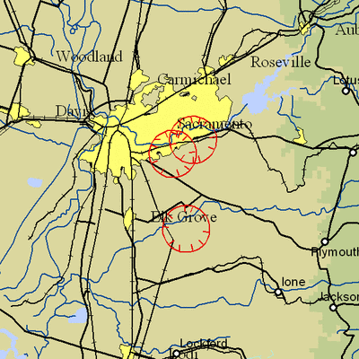
Location: Wilton, California
Beginning Date and Time: April 11, 2008 at 2050 UTC
Ending Date and Time: April 12, 2008 at 0220 UTC
Reason for NOTAM: Temporary flight restrictions for VIP (Very
Important Person) Movement
Type: VIP
Replaced NOTAM(s): 8/2008: Due to Updated times
Affected Area(s)
Area A
Airspace Definition:
Center: On the MC CLELLAN VOR/DME (MCC) 127 degree radial at
7.5 nautical miles. (Latitude: 38º33'55"N, Longitude:
121º18'39"W)
Radius: 3 nautical miles
Altitude: From the surface up to but not including 3000 feet
AGL
Effective Date(s):
From April 11, 2008 at 2050 UTC (April 11, 2008 at 1350
PDT)
To April 11, 2008 at 2140 UTC (April 11, 2008 at 1440
PDT)
Area B
Airspace Definition:
Center: On the MC CLELLAN VOR/DME (MCC) 103 degree radial at
7.3 nautical miles. (Latitude: 38º36'21"N, Longitude:
121º16'10"W)
Radius: 3 nautical miles
Altitude: From the surface up to but not including 3000 feet
AGL
Effective Date(s):
From April 11, 2008 at 2110 UTC (April 11, 2008 at 1410
PDT)
To April 11, 2008 at 2350 UTC (April 11, 2008 at 1650
PDT)
Area C
Airspace Definition:
Center: On the MC CLELLAN VOR/DME (MCC) 132 degree radial at
17.1 nautical miles. (Latitude: 38º25'17"N, Longitude:
121º13'06"W)
Radius: 3 nautical miles
Altitude: From the surface up to but not including 3000 feet
AGL
Effective Date(s):
From April 11, 2008 at 2335 UTC (April 11, 2008 at 1635
PDT)
To April 12, 2008 at 0145 UTC (April 11, 2008 at 1845
PDT)
Area D
Airspace Definition:
Center: On the MC CLELLAN VOR/DME (MCC) 127 degree radial at
7.5 nautical miles. (Latitude: 38º33'55"N, Longitude:
121º18'39"W)
Radius: 3 nautical miles
Altitude: From the surface up to but not including 3000 feet
AGL
Effective Date(s):
From April 12, 2008 at 0130 UTC (April 11, 2008 at 1830
PDT)
To April 12, 2008 at 0220 UTC (April 11, 2008 at 1920
PDT)
Operating Restrictions and Requirements
No pilots may operate an aircraft in the areas covered by this
NOTAM (except as described).
Unless otherwise authorized by ATC.
Other Information:
ARTCC: ZOA - Oakland Center
Authority: Title 14 CFR section 91.141
FMI: www.tfr.faa.gov,
Depicted TFR data may not be a complete listing. Pilots should not
use the information on this website for flight planning purposes.
For the latest information, call your local Flight Service Station
at 1-800-WX-BRIEF.
More News
“We respectfully call on the City of Mesa to: 1. Withdraw the landing fee proposal immediately 2. Engage with the aviation community before making decisions that impact safet>[...]
High Speed Taxiway A long radius taxiway designed and provided with lighting or marking to define the path of aircraft, traveling at high speed (up to 60 knots), from the runway ce>[...]
Aero Linx: International Federation of Airworthiness (IFA) IFA uniquely combines together all those with responsibility for policies, principles and practices concerned with the co>[...]
Controller’s Expectation That VW02 Would Have Departed Sooner Led To An Inadequate Scan And Loss Of Situational Awareness Analysis: A Robinson R-44 helicopter N744AF, VW02 (V>[...]
A Few Questions AND Answers To Help You Get MORE Out of ANN! 1) I forgot my password. How do I find it? 1) Easy... click here and give us your e-mail address--we'll send it to you >[...]
 Aero-News: Quote of the Day (12.09.25)

