The View From Up Here | Aero-News Network
Aero-News Network
RSS icon RSS feed
podcast icon MP3 podcast
Subscribe Aero-News e-mail Newsletter Subscribe

Airborne Unlimited -- Most Recent Daily Episodes

Episode Date

Airborne-Monday

Airborne-Tuesday

Airborne-Wednesday Airborne-Thursday

Airborne-Friday

Airborne On YouTube

Airborne-Unlimited-11.10.25

AirborneNextGen-
11.11.25

Airborne-Unlimited-11.12.25

Airborne-Unlimited-11.06.25

AirborneUnlimited-11.07.25

LIVE MOSAIC Town Hall (Archived): www.airborne-live.net

Thu, May 13, 2004

The View From Up Here

True To Life Scenery Of "The City By The Bay" For Microsoft Flight Simulator

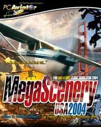
MegaScenery publisher, PC Aviator, today announced that the third volume of MegaScenery – Northern California, featuring San Francisco, Sacramento and 38,000 square miles of surrounding countryside has gone gold and is scheduled for release on 7 June 2004.

Bigger, better and prettier than previous MegaScenery areas, "MegaScenery Volume 3: Northern California" has been recreated from 5 meter satellite imagery and puts Microsoft Flight Simulator pilots up there in the skies above this diversely picturesque region of the United States.

San Francisco, Oakland, Sacramento, down to Monterey bay and inland to the W120.5 longitudinal line…. and everything else in between: Flight Simulator pilots will be able to take to the skies and navigate this expansive scenery identifying everything down to individual rooftops on houses.

Aerosoft Australia, developers of MegaScenery, have continued to enhance MegaScenery technology and this volume comes with even further improved night scenery. 

It also incorporates high-resolution 30 meter terrain mesh for elevation data resulting in even more realistic mountains and valleys.

While there are other photo-realistic scenery products available only MegaScenery provides complete night scenery for the entire area so users get both a day and night VFR flying experience.

Just like the previous titles and all future MegaScenery titles, the Northern California package comes with all of the real world aeronautical charts required to fly the scenery [like a pilot] and to identify all of the major landmarks the scenery contains.

FMI: http://www.megascenery.com

Advertisement

More News

NTSB Prelim: Sikorsky UH60 Sikorsky UH-60

Sikorsky UH-60 Black Hawk Helicopter Collided With An Unregistered DJI Mavic 3T Unmanned Aerial Vehicle On July 7, 2025, about 1557 central daylight time, an unregistered Sikorsky >[...]

Aero-News: Quote of the Day (11.13.25)

“After considering the measures taken, minimum liquidity covenants in the Company's current debt obligations and cash flows to maintain current operational obligations requir>[...]

ANN's Daily Aero-Term (11.13.25): Ground Clutter

Ground Clutter A pattern produced on the radar scope by ground returns which may degrade other radar returns in the affected area. The effect of ground clutter is minimized by the >[...]

ANN's Daily Aero-Linx (11.13.25)

Aero Linx: Warbirds of America The EAA Warbirds of America, a division of the Experimental Aircraft Association in Oshkosh, Wisconsin, is a family of owners, pilots and enthusiasts>[...]

Airborne 11.07.25: Affordable Expo Starts!, Duffy Worries, Isaacman!

Also: Louisville UPS Crash Aftermath, Taiwan Boosts Pilot Pool, Spartan Acquires, DON’T MISS the MOSAIC Town Hall! This three-day Affordable Flying Expo brings together indoo>[...]

blog comments powered by Disqus


Advertisement

Advertisement

Podcasts

Advertisement

© 2007 - 2025 Web Development & Design by Pauli Systems, LC