Airbus And ZF To Develop Highly Precise End-To-End Autonomous Driving Solution | Aero-News Network
Aero-News Network
RSS icon RSS feed
podcast icon MP3 podcast
Subscribe Aero-News e-mail Newsletter Subscribe

Airborne Unlimited -- Most Recent Daily Episodes

Episode Date

Airborne-Monday

Airborne-Tuesday

Airborne-Wednesday Airborne-Thursday

Airborne-Friday

Airborne On YouTube

Airborne-Unlimited-05.05.25

Airborne-NextGen-05.06.25

AirborneUnlimited-05.07.25

Airborne-Unlimited-05.01.25

AirborneUnlimited-05.02.25

Sat, Apr 20, 2019

Airbus And ZF To Develop Highly Precise End-To-End Autonomous Driving Solution

Will Utilize Radar Satellite Imagery Provided By Airbus

Airbus Defence and Space and ZF Friedrichshafen AG, a system provider for mobility, are collaborating to enrich and complement ZF on-board system to enhance autonomous driving by using Airbus satellite derived information.

Under this collaboration, Airbus and ZF are combining their capabilities and expertise to offer a reliable end-to-end solution for self-driving and self-positioning vehicles. To answer the extreme level of accuracy required, Airbus provides its unique high precise Ground Control Points (GCPs), calculated using radar satellite imagery, to support the fusion of ZF sensor data such as Lidar and Radar. In addition, the GCPs serve as independent data source to improve and validate the accuracy of mobile mapping data.

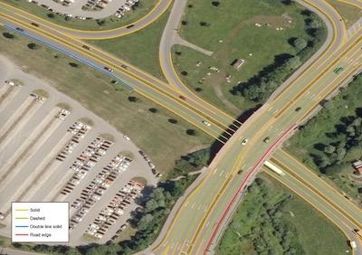
Furthermore Airbus investigates generation of High Definition maps (HD maps) based on aerial and space borne approach, to complement ZF semantic cards. HD Maps are key to ensure the guiding route, as they build an important link between mobile mapping data and global positioning systems. They contain more information than just the road itself, as lanes, the radius of curves, lane widths, street signs, bridges, and buildings, as well as their distance from one another. Both remote sensed information GCPs and HD maps will be integrated as foundation layers into the “ZF AD Environment” – an enhanced HD maps solution ZF will present soon – where all needed information for autonomous driving will be implemented in a cloud based system.

Autonomous driving is a new, enthusing and challenging market for Airbus, as the highest level of autonomy requires the highest maps precision.

(Image provided with Airbus news release)

FMI: www.airbus.com

Advertisement

More News

ANN's Daily Aero-Term (05.05.25): Circle To Runway (Runway Number)

Circle To Runway (Runway Number) Used by ATC to inform the pilot that he/she must circle to land because the runway in use is other than the runway aligned with the instrument appr>[...]

ANN's Daily Aero-Linx (05.05.25)

Aero Linx: National Aviation Safety Foundation (NASF) The National Aviation Safety Foundation is a support group whose objective is to enhance aviation safety through educational p>[...]

NTSB Prelim: De Havilland DHC-1

At Altitude Of About 250-300 Ft Agl, The Airplane Experienced A Total Loss Of Engine Power On November 6, 2024, at 1600 central standard time, a De Havilland DHC-1, N420TD, was inv>[...]

Classic Aero-TV: The Boeing Dreamliner -- Historic First Flight Coverage

From 2009 (YouTube Edition): Three Hour Flight Was 'Flawless' -- At Least, Until Mother Nature Intervened For anyone who loves the aviation business, this was a VERY good day. Afte>[...]

Airborne-NextGen 05.06.25: AF Uncrewed Fighters, Drones v Planes, Joby Crew Test

Also: AMA Names Tyler Dobbs, More Falcon 9 Ops, Firefly Launch Unsuccessful, Autonomous F-16s The Air Force has begun ground testing a future uncrewed jet design in a milestone tow>[...]

blog comments powered by Disqus


Advertisement

Advertisement

Podcasts

Advertisement

© 2007 - 2025 Web Development & Design by Pauli Systems, LC