Alaska Governor Announces Aviation Safety Plan | Aero-News Network
Aero-News Network
RSS icon RSS feed
podcast icon MP3 podcast
Subscribe Aero-News e-mail Newsletter Subscribe

Airborne Unlimited -- Most Recent Daily Episodes

Episode Date

Airborne-Monday

Airborne-Tuesday

Airborne-Wednesday Airborne-Thursday

Airborne-Friday

Airborne On YouTube

Airborne-Unlimited-11.10.25

AirborneNextGen-
11.11.25

Airborne-Unlimited-11.12.25

Airborne-Unlimited-11.06.25

AirborneUnlimited-11.07.25

LIVE MOSAIC Town Hall (Archived): www.airborne-live.net

Sun, Jan 27, 2008

Alaska Governor Announces Aviation Safety Plan

Avionics Funding Bills Pending In Legislature

Alaska Governor Sarah Palin unveiled Saturday details of a new aviation safety initiative.

With seven times the licensed pilots of any other state, Alaska also has the highest accident rate nationwide. Bad weather and harsh terrain contribute significantly to that statistic, according to the State of Alaska website.

The administration's plan is a multi-departmental effort that includes a bill that will establish a new loan program in the Department of Commerce, Community & Economic Development. Under this program, low interest loans will be available for the purchase and installation of advanced satellite-based aircraft avionics.

Governor Palin's plan to improve aviation safety is a critical component of the Federal Aviation Administration's plan to invest over $400 million dollars in the installation, operation and maintenance of the ground stations as part of its "Capstone" aviation safety program.

ANN recently reported on the FAA's request for the State of Alaska to provide $34 million to outfit 4,000 aircraft with Automatic Dependent Surveillance - Broadcast (ADS-B) avionics over the next five years.

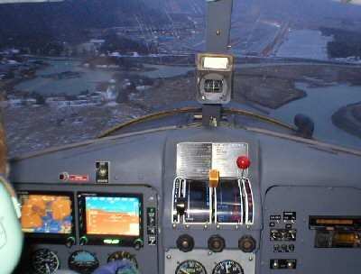
Pilots flying such equipped aircraft will be able to view their exact position, groundspeed, position relative to altitude and terrain, course, destination, and position relative to other such equipped aircraft.

Real-time weather condition information will also be available, providing invaluable assistance in avoiding weather-related accidents.
 
"In addition to reducing aircraft accidents, such equipped aircraft will offer safer access to rural communities," Governor Palin said. "This new technology will also increase the safety and effectiveness of medical evacuations and search-and-rescue operations."

Creating new digital maps of the entire state is another safety effort. These maps, used by the new avionics, will feature accurate height and depth data of physical terrain that will be incorporated into the FAA's terrain models.

The Department of Military and Veterans Affairs is also working with The Medallion Foundation to provide updated map data in flight simulators. This allows pilots to receive very accurate and realistic training for flying in Alaska's rugged environment.

House Bill 340 and Senate Bill 249 are pending in the Alaska Legislature to establish the avionics loan program.

FMI: www.gov.state.ak.us; www.faa.gov  

Advertisement

More News

ANN FAQ: Contributing To Aero-TV

How To Get A Story On Aero-TV News/Feature Programming How do I submit a story idea or lead to Aero-TV? If you would like to submit a story idea or lead, please contact Jim Campbel>[...]

Classic Aero-TV: Bob Hoover At Airventure -- Flight Test and Military Service

From 2011 (YouTube Edition): Aviation's Greatest Living Legend Talks About His Life In Aviation (Part 5, Final) ANN is pleased to offer you yet another snippet from the public conv>[...]

Aero-News: Quote of the Day (11.12.25)

“All Air Traffic Controllers must get back to work, NOW!!! Anyone who doesn’t will be substantially ‘docked. For those Air Traffic Controllers who were GREAT PATR>[...]

ANN's Daily Aero-Linx (11.12.25)

Aero Linx: American Navion Society Welcome to the American Navion Society. Your society is here to support the Navion community. We are your source of technical and operating infor>[...]

ANN's Daily Aero-Term (11.12.25): Glideslope Intercept Altitude

Glideslope Intercept Altitude The published minimum altitude to intercept the glideslope in the intermediate segment of an instrument approach. Government charts use the lightning >[...]

blog comments powered by Disqus


Advertisement

Advertisement

Podcasts

Advertisement

© 2007 - 2025 Web Development & Design by Pauli Systems, LC