CAP Provides Aerial Recon Photos Of Red River Flooding | Aero-News Network
Aero-News Network
RSS icon RSS feed
podcast icon MP3 podcast
Subscribe Aero-News e-mail Newsletter Subscribe

Airborne Unlimited -- Most Recent Daily Episodes

Episode Date

Airborne-Monday

Airborne-Tuesday

Airborne-Wednesday Airborne-Thursday

Airborne-Friday

Airborne On YouTube

Airborne-Unlimited-05.05.25

Airborne-NextGen-05.06.25

AirborneUnlimited-05.07.25

Airborne-Unlimited-05.01.25

AirborneUnlimited-05.02.25

Tue, Apr 19, 2011

CAP Provides Aerial Recon Photos Of Red River Flooding

North Dakota Wing Flying Four To Five Sorties Per Day

With spring flooding nearing high-water marks once again in the Red River Valley, volunteers from Civil Air Patrol's North Dakota Wing are flying daily, using the latest in digital airborne photography equipment to help emergency management officials assess damages and deploy assets to the region. "We've been flying multiple sorties - four or five flights a day - for about a week now," said Lt. Col. William E. Kay, the wing's interim commander.

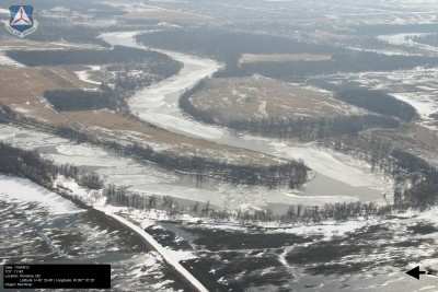
CAP's aircraft provide the perfect vantage point for reconnaissance photos, which are tagged with the date and GPS coordinates. The photos are providing emergency response decision-makers with the North Dakota Department of Emergency Services, the U.S. Department of Homeland Security and the Federal Emergency Management Agency with the latest information they need to assess damages and deploy assets throughout the region.

The flooding in the Red River Valley is starting to peak in Fargo, the state's largest city, Kay said, with much of the floodwaters from a record winter snow pack and iced-over ponds and lakes "rolling north now." The Red River flows north along the North Dakota and Minnesota border toward Grand Forks, ultimately reaching Lake Winnipeg in Canada.


CAP Red River Aerial Photo Taken During 2010 Season

Such a mission is a ritual each spring for the North Dakota Wing as well as other CAP wings in the upper Midwest. "We started in earnest on March 16 and made practice flights even before that," Kay said. "And we've been going at it since."

In spring 2010, CAP aircraft and volunteers from seven wings provided nearly 360 hours of flight time and delivered thousands of photos supporting disaster relief efforts in North Dakota and Minnesota, as well as South Dakota. The images were used to determine the extent of flooding along the Red River and other rivers and tributaries as they crested, as well as to help analyze the integrity of several earthen dams. They also helped officials improve the snow melt models used to predict water levels for the river and its tributaries.

FMI: www.gocivilairpatrol.com

Advertisement

More News

ANN's Daily Aero-Linx (05.06.25)

Aero Linx: International Federation of Airworthiness (IFA) We aim to be the most internationally respected independent authority on the subject of Airworthiness. IFA uniquely combi>[...]

ANN's Daily Aero-Term (05.06.25): Ultrahigh Frequency (UHF)

Ultrahigh Frequency (UHF) The frequency band between 300 and 3,000 MHz. The bank of radio frequencies used for military air/ground voice communications. In some instances this may >[...]

ANN FAQ: Q&A 101

A Few Questions AND Answers To Help You Get MORE Out of ANN! 1) I forgot my password. How do I find it? 1) Easy... click here and give us your e-mail address--we'll send it to you >[...]

Classic Aero-TV: Virtual Reality Painting--PPG Leverages Technology for Training

From 2019 (YouTube Edition): Learning To Paint Without Getting Any On Your Hands PPG's Aerospace Coatings Academy is a tool designed to teach everything one needs to know about all>[...]

Airborne 05.02.25: Joby Crewed Milestone, Diamond Club, Canadian Pilot Insurance

Also: Sustainable Aircraft Test Put Aside, More Falcon 9 Ops, Wyoming ANG Rescue, Oreo Cookie Into Orbit Joby Aviation has reason to celebrate, recently completing its first full t>[...]

blog comments powered by Disqus


Advertisement

Advertisement

Podcasts

Advertisement

© 2007 - 2025 Web Development & Design by Pauli Systems, LC