Airbus Extends Its Reach Into Precision Agriculture Solutions With AgNeo | Aero-News Network
Aero-News Network
RSS icon RSS feed
podcast icon MP3 podcast
Subscribe Aero-News e-mail Newsletter Subscribe

Airborne Unlimited -- Most Recent Daily Episodes

Episode Date

Airborne-Monday

Airborne-Tuesday

Airborne-Wednesday Airborne-Thursday

Airborne-Friday

Airborne On YouTube

Airborne-Unlimited-09.15.25

AirborneNextGen-
09.09.25

Airborne-Unlimited-09.10.25

Airborne-AffordableFlyers-09.11.25

AirborneUnlimited-09.12.25

Mon, Mar 16, 2020

Airbus Extends Its Reach Into Precision Agriculture Solutions With AgNeo

A New Precision Farming Solution For Commodity And Permanent Crops

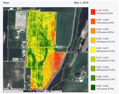
Airbus has launched AgNeo, its new integrated precision farming solution for commodity and permanent crops. Delivering in-season actionable information based on satellite imagery and premium agronomic analytics, AgNeo will help customers save time, optimise inputs and increase yields.

AgNeo leverages Airbus’ 30-year experience in the agriculture market and the long-standing and fruitful collaboration with its customers to propose a wide range of crop analytics. Based on imagery-derived health maps from SPOT, Pléiades, Sentinel-2 and Landsat 8 data, they support a wide range of capabilities: from alerting features that direct agronomists to scout areas in their fields that require immediate attention, to the creation of management zones and variable rate application maps. Thanks to an Airbus-proprietary processing chain that normalizes data across all sensors, AgNeo customers can also derive absolute agronomic indicators to use as input to their own models for building nitrogen recommendation or establishing water budgets.

AgNeo also provides enhanced analytics for high value permanent crops such as almonds, apples and grapes. Using 20-inch resolution data from Pléiades, AgNeo creates a mask of all the tree crowns to remove noise from background vegetation and soil, improving the results and bringing analytics to the tree level. These analytics include a stand count inventory eliminating time-consuming and error-prone manual tree counts. The product will be able to utilize 12-inch data from Airbus’ new Pléiades Neo satellites due to be launched later this year.

The AgNeo solution is available with a full user interface and will also be accessible via APIs.

(Image provided with Airbus news release)

FMI: www.airbus.com

Advertisement

More News

ANN's Daily Aero-Term (09.13.25): Center Weather Advisory

Center Weather Advisory An unscheduled weather advisory issued by Center Weather Service Unit meteorologists for ATC use to alert pilots of existing or anticipated adverse weather >[...]

Aero-News: Quote of the Day (09.13.25)

“HITRON embodies the Coast Guard’s spirit of innovation and adaptability. From its humble beginnings as a prototype program, it has evolved into a vital force in our co>[...]

ANN's Daily Aero-Linx (09.13.25)

Aero Linx: International Airline Medical Association (IAMA) The International Airline Medical Association (IAMA), formerly known as the Airline Medical Directors Association (AMDA)>[...]

Classic Aero-TV: Hover Camera Passport - A Gesture Controlled Selfie Drone

From 2017 (YouTube Edition): It’s So Simple to Operate, Anyone Can Do It… And We’re Not Kidding The drones were up and flying at the Consumer Electronics Show he>[...]

Airborne-NextGen 09.09.25: Textron Nixes ePlane, Joby L/D Flt, Swift Approval

Also: Space Command Moves, Alpine Eagle, Duffy Names Amit Kshatriya, Sikorsky-CAL FIRE Collab Textron eAviation is putting the development of its Nexus electric vertical takeoff an>[...]

blog comments powered by Disqus


Advertisement

Advertisement

Podcasts

Advertisement

© 2007 - 2025 Web Development & Design by Pauli Systems, LC