Le Québec Brûle
Over summers past, smoke born of wildfires up Canada way has passed largely unnoticed over the U.S.—primarily by virtue of its high altitude.
Not so in 2023.
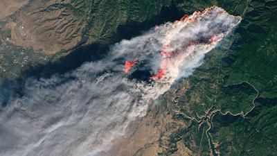
In the first week of June, low visibility instantiated by smoke from wildfires in the Canadian Province of Quebec occasioned flight delays, cancellations, and ground stops at New York’s LaGuardia (LGA) and Kennedy (JFK) International Airports, as well as New Jersey’s Newark Liberty (EWR) airport. In addition to wreaking havoc on the orderly flow of air-traffic along America’s Eastern Seaboard, the smoke degraded the quality of surface air breathed by tens of millions of New England residents.
Winds typically impel smoke from fires in Quebec, Newfoundland, and Labrador eastward over the North Atlantic. However, in June 2023, a persistent coastal low centered near Canada’s Prince Edward Island instead forced smoke south, into the United States.
Smoke currently reaching the northeastern U.S. from Canada has raised the concentration of fine particulate matter suspended in the air to upwards of four-hundred-micrograms per-cubic-meter—the highest-ever recordings since routine measurements began in 1999.
Ryan Stauffer, an atmospheric scientist based at NASA’s Goddard Space Flight Center, stated: “The surface smoke pollution from New York to the D.C. region is easily the most significant since at least July 2002, when a similar situation occurred with nearby fires in Quebec. This event is rivaling, and in some cases will likely surpass, the observed 2002 smoke pollution.”
According to Mr. Stauffer, the air quality index in New York City surpassed 175 (Code Red) on 06 June, topping the previous record of 167 set in 2002. The following day, “the D.C. region joined New York City and experienced some of its most smoke-polluted air in the past 25 years,” Stauffer set forth.
NASA’s Terra, Aqua, and Aura satellites have observed the extent to which smoke particles affect the transmission, absorption, and reflection of sunlight through Earth’s atmosphere (aerosol optical depth). Similarly, the space agency’s Cloud-Aerosol Lidar and Infrared Pathfinder Satellite Observation (CALIPSO) mission has collected observations of smoke height. What’s more, data from NASA’s ground-based Micro-Pulse Lidar Network (MPLNET) and Aerosol Robotic Network (AERONET) indicate—somewhat anticlimactically—a significant amount of smoke is present near the Earth’s surface in the vicinity of the fires.
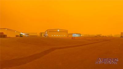
As ground-level smoke of the thickness currently observed is rare in the eastern U.S., residents of the New England and the Great Lakes states have been taken aback by the dramatic, often unsettling optical effects smoke is wont to have on sunlight.
Mr. Stauffer explained: “Smoke particles scatter and absorb shorter wavelengths of sunlight like blues, greens, and yellows more easily compared to the longer-wavelength oranges and reds; so we see muted red sunrises and sunsets under heavy smoke conditions. In extreme cases, like this week, the sun may become obscured entirely.”
Speaking to the subject of a multi-layered smoke-plume observed over Lanham, Maryland, on 07 June, atmospheric scientist Colin Seftor of Science Systems and Applications, Inc. remarked: “There are different histories to each one of those layers that would be interesting to untangle. The layer lurking at 12-kilometers is a month old and can actually be traced back to intense fires in Alberta on 05 May.”
 NTSB Final Report: Patriot Aircraft LLC CX1900A

