Robinson Intro's Moving Map for R44 Police Helo | Aero-News Network
Aero-News Network
RSS icon RSS feed
podcast icon MP3 podcast
Subscribe Aero-News e-mail Newsletter Subscribe

Airborne Unlimited -- Most Recent Daily Episodes

Episode Date

Airborne-Monday

Airborne-Tuesday

Airborne-Wednesday Airborne-Thursday

Airborne-Friday

Airborne On YouTube

Airborne-Unlimited-11.17.25

AirborneNextGen-
11.11.25

Airborne-Unlimited-11.12.25

Airborne-FltTraining-11.13.25

AirborneUnlimited-11.14.25

LIVE MOSAIC Town Hall (Archived): www.airborne-live.net

Mon, Oct 24, 2005

Robinson Intro's Moving Map for R44 Police Helo

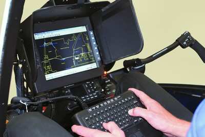
A new GPS moving map system is now available for the R44 Raven II Police Helicopter. To create the system Robinson combined software designed by Greg Taylor of Flight Management Systems with existing R44 hardware. With this combination the operator can type in a particular address, which is then displayed on a street map showing the location of the address along with the position of the helicopter.

Direction, distance, and estimated time of arrival are also displayed, providing the police with an easy-to-use map to guide them to their destination.

The FAA-approved installation includes a Stealth personal computer with Intel 1.2 GHz Celeron processor, custom keyboard and moving map software. The image is displayed on the same 10-inch Transvideo fold-down monitor currently used with the FLIR infrared camera system.

Buttons on the screen allow the observer to switch between the FLIR images and map display. GPS helicopter position data is provided by the Garmin 420 GPS/Com, standard equipment on the Police Helicopter.

The onboard computer system also accommodates a mobile data terminal “MDT” system which allows two-way communication with the dispatch computers at the police station and in squad cars. The observer can obtain unit status, vehicle descriptions, active call information, and respond to calls directly through the computer. Call addresses posted on the dispatch screen can be pasted directly into the moving map address window, eliminating keystrokes and reducing response time.

List price for the moving map option is US $15,000 which includes installation of parcel map data (supplied by police agency where available). Weight of the added optional equipment is approximately 10 lbs. After six months of testing the system in his R44 Police Helicopter, Leo Bell of CA Aviation Services feels that “with the moving map and MDT system, the R44 is now one of the best equipped police helicopters available.”

FMI: www.robinsonheli.com

Advertisement

More News

NTSB Prelim: Funk B85C

According To The Witness, Once The Airplane Landed, It Continued To Roll In A Relatively Straight Line Until It Impacted A Tree In His Front Yard On November 4, 2025, about 12:45 e>[...]

Aero-News: Quote of the Day (11.21.25)

"In the frame-by-frame photos from the surveillance video, the left engine can be seen rotating upward from the wing, and as it detaches from the wing, a fire ignites that engulfs >[...]

ANN's Daily Aero-Term (11.21.25): Radar Required

Radar Required A term displayed on charts and approach plates and included in FDC NOTAMs to alert pilots that segments of either an instrument approach procedure or a route are not>[...]

Classic Aero-TV: ScaleBirds Seeks P-36 Replica Beta Builders

From 2023 (YouTube Edition): It’s a Small World After All… Founded in 2011 by pilot, aircraft designer and builder, and U.S. Air Force veteran Sam Watrous, Uncasville,>[...]

Airborne 11.21.25: NTSB on UPS Accident, Shutdown Protections, Enstrom Update

Also: UFC Buys Tecnams, Emirates B777-9 Buy, Allegiant Pickets, F-22 And MQ-20 The NTSB's preliminary report on the UPS Flight 2976 crash has focused on the left engine pylon's sep>[...]

blog comments powered by Disqus


Advertisement

Advertisement

Podcasts

Advertisement

© 2007 - 2025 Web Development & Design by Pauli Systems, LC