Vermont Becomes First State To Use SARMaster | Aero-News Network
Aero-News Network
RSS icon RSS feed
podcast icon MP3 podcast
Subscribe Aero-News e-mail Newsletter Subscribe

Airborne Unlimited -- Most Recent Daily Episodes

Episode Date

Airborne-Monday

Airborne-Tuesday

Airborne-Wednesday Airborne-Thursday

Airborne-Friday

Airborne On YouTube

Airborne-Unlimited-06.23.25

Airborne-NextGen-06.24.25

AirborneUnlimited-06.25.25

Airborne-AffordableFlyers-06.26.25

AirborneUnlimited-06.27.25

Thu, Nov 18, 2004

Vermont Becomes First State To Use SARMaster

System Used To Coordinate Rescues

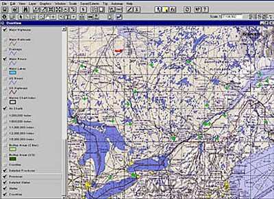
EMS Technologies says its SARMaster search-and-rescue (SAR) information system is now installed in the Vermont State Police's 24/7 dispatch center in Waterbury (VT). The EMS software is being used to process Personal Locator Beacon (PLB) alerts. PLBs were made available to the 48 contiguous states in the United States on July 1, 2003, but this is the first statewide implementation of that technology. The announcement came at the Emergency Response 2004 Exhibition & Conference in San Diego (CA).

When a PLB is set off, SARMaster can detect the location of the alert within a kilometer. For GPS-equipped PLBs, the SARMaster software can narrow the location to within 500 meters.

The Air Force Rescue Coordination Center (AFRCC) at Langley Air Force Base, already a user of SARMaster when it receives distress alerts in its national center, has contracted with EMS to deploy SARMaster at the state level to support local rescue activities.

"The State of Vermont is the first site in the United States to roll out SARMaster, and is the first state to be fully operational for tracking PLB alerts wherever they occur in the state," said Dr. Neil Mackay, senior vice president and general manager, EMS Technologies' SATCOM Division. "Time is a critical commodity during a search-and-rescue operation, and SARMaster's GIS information mapping, incident management and other capabilities are ideal for supporting local rescue operations when seconds count."

While Vermont has not yet had any live PLB activations, Lt. Jocelyn Stohl, the state SAR coordinator and a member of the Vermont State Police, predicts that PLBs will become an attractive option for outdoor enthusiasts, including the operators of large outdoor facilities, such as ski resorts. She says the PLB technology and SARMaster software will allow rescue teams to narrow the search area much more quickly, which is critical in a state that has varied terrain and is marked by mountain ranges running north and south across the state. Calling SARMaster "user friendly," Stohl said, "The biggest potential we see with the system is we can locate individuals much more quickly. That will make rescue missions shorter in duration because we have a much more pinpointed area where lost individuals can be found, which, in turn, will reduce costs to the state."

SARMaster was designed by EMS SATCOM Division's Emergency Management Product Group to meet the specialized needs of Search & Rescue (SAR) controllers and Rescue Coordination Centers (RCC) around the world. SARMaster provides controllers with an integrated spatial/textual view of information to effectively prosecute SAR incidents. Developed under the Windows operating system, SARMaster supports dual monitor capabilities for simultaneously viewing of spatial and textual information in a networked configuration, or can be configured for use with portable, stand-alone units.

EMS SATCOM has provided ground equipment and management systems for use with the COSPAS-SARSAT satellite system since its launch in 1981. Since that time, the system has been credited with saving more than 15,000 lives by using spacecraft and ground facilities to detect and locate signals from distress beacons.

FMI: www.ems-t.com

Advertisement

More News

ANN's Daily Aero-Linx (06.29.25)

Aero Linx: Transport Canada We are a federal institution, leading the Transport Canada portfolio and working with our partners. Transport Canada is responsible for transportation p>[...]

ANN's Daily Aero-Term (06.29.25): Gross Navigation Error (GNE)

Gross Navigation Error (GNE) A lateral deviation from a cleared track, normally in excess of 25 Nautical Miles (NM). More stringent standards (for example, 10NM in some parts of th>[...]

Classic Aero-TV: Anticipating Futurespace - Blue Origin Visits Airventure 2017

From AirVenture 2017 (YouTube Edition): Flight-Proven Booster On Display At AirVenture… EAA AirVenture Oshkosh is known primarily as a celebration of experimental and amateu>[...]

NTSB Final Report: Cirrus SR22

Aircraft Parachute System (CAPS) Was Deployed About 293 Ft Above Ground Level, Which Was Too Low To Allow For Full Deployment Of The Parachute System Analysis: The day before the a>[...]

Airborne Affordable Flyers 06.26.25: PA18 Upgrades, ‘Delta Force’, Rhinebeck

Also: 48th Annual Air Race Classic, Hot Air Balloon Fire, FAA v Banning 100LL, Complete Remote Pilot The news Piper PA-18 Super Cub owners have been waiting for has finally arrived>[...]

blog comments powered by Disqus


Advertisement

Advertisement

Podcasts

Advertisement

© 2007 - 2025 Web Development & Design by Pauli Systems, LC