Signs Of Ancient Mars Lakes And Quakes Seen In New Map | Aero-News Network
Aero-News Network
RSS icon RSS feed
podcast icon MP3 podcast
Subscribe Aero-News e-mail Newsletter Subscribe

Airborne Unlimited -- Most Recent Daily Episodes

Episode Date

Airborne-Monday

Airborne-Tuesday

Airborne-Wednesday Airborne-Thursday

Airborne-Friday

Airborne On YouTube

Airborne-Unlimited-05.05.25

Airborne-NextGen-05.06.25

AirborneUnlimited-05.07.25

Airborne-Unlimited-05.01.25

AirborneUnlimited-05.02.25

Mon, Dec 22, 2014

Signs Of Ancient Mars Lakes And Quakes Seen In New Map

Images From MRO Released By USGS

Long ago, in the largest canyon system in our solar system, vibrations from "marsquakes" shook soft sediments that had accumulated in Martian lakes.

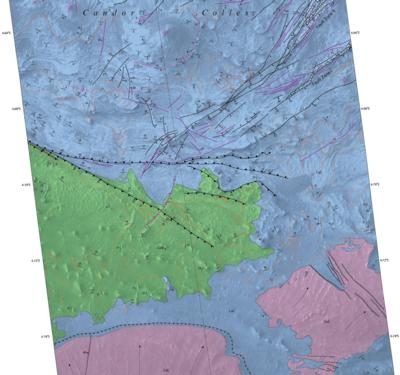
The shaken sediments formed features that now appear as a series of low hills apparent in a geological map based on NASA images. The map was released today by the U.S. Geological Survey (USGS).

This map of the western Candor Chasma canyon within Mars' Valles Marineris is the highest-resolution Martian geological map ever relased by USGS. It is derived from images taken by the High Resolution Imaging Science Experiment (HiRISE) camera on NASA's Mars Reconnaissance Orbiter, which reveal details smaller than a desk.

"This new map shows that at the time these sediments were deposited, a part of west Candor Chasma, specifically Condor Colles, contained numerous shallow, spring-fed lakes," said map author Chris Okubo of the USGS Astrogeology Science Center, Flagstaff, Arizona. "These lakes helped to trap wind-blown sand and dust, which accumulated over time and formed the extensive sedimentary deposits we see today."

The wet sediments experienced seismic shaking in "marsquakes" related to movement along several large geological faults in the area. A series of low hills resulted.

Valles Marineris is more than 2,500 miles (4,000 kilometers) long. The conditions under which sedimentary deposits in it formed have been an open issue for decades. Possibilities proposed have included accumulation in lakebeds, volcanic eruptions under glaciers within the canyons, and accumulation of wind-blown sand and dust.

HiRISE is operated by the University of Arizona, Tucson. The instrument was built by Ball Aerospace & Technologies Corp. of Boulder, Colorado. The Mars Reconnaissance Orbiter Project is managed for NASA's Science Mission Directorate in Washington, by NASA's Jet Propulsion Laboratory, Pasadena, California, a division of the California Institute of Technology, also in Pasadena.

(Image provided by USGS)

FMI: Download MapUSGS Blog

Advertisement

More News

NTSB Final Report: Cessna 177B

Outboard Section Of The Right Wing And The Right Flap Separated In Flight And The Airplane Impacted A Farm Field Analysis: The pilot was approaching his destination airport under i>[...]

ANN's Daily Aero-Term (05.08.25): Final Approach Fix

Final Approach Fix The fix from which the final approach (IFR) to an airport is executed and which identifies the beginning of the final approach segment. It is designated on Gover>[...]

Aero-News: Quote of the Day (05.08.25)

"Our choice of when to respond, how to respond and on which targets to respond is a consideration that we make every time... Netanyahu also noted that anyone attacking Israel &ldqu>[...]

ANN's Daily Aero-Term (05.09.25): Estimated (EST)

Estimated (EST) When used in NOTAMs “EST” is a contraction that is used by the issuing authority only when the condition is expected to return to service prior to the e>[...]

ANN's Daily Aero-Linx (05.09.25)

Aero Linx: Coalition of Airline Pilots Associations (CAPA) The Coalition of Airline Pilots Associations (CAPA) is the world’s largest pilot trade association representing ove>[...]

blog comments powered by Disqus


Advertisement

Advertisement

Podcasts

Advertisement

© 2007 - 2025 Web Development & Design by Pauli Systems, LC