Wed, Jul 14, 2010
Western Virginia Aviators Say Poor Mountain Is A Poor
Site For Wind Farm
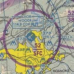 A proposed wind farm consisting of
15 to 18 wind turbine generators near Roanoke Regional Airport
(KROA) in Western Virginia has gotten the attention of a
pilots' group in the area.
A proposed wind farm consisting of
15 to 18 wind turbine generators near Roanoke Regional Airport
(KROA) in Western Virginia has gotten the attention of a
pilots' group in the area.
A company called Invenergy applied to the FAA for a "hazard
determination" to see if they could build windmills on top of Poor
Mountain, where there are already a number of radio and other
communications towers. But the wind turbines would be over 440 feet
tall, which is about twice as tall as any existing tower on the
mountain.
Matthew Broughton, an aviation lawyer and president of the IFR
Pilots Club in Roanoke, said the wind turbines would create a
hazard to navigation, particularly when the condition are IFR.
Aircraft on IFR approaches to Roanoke usually use runway 6, and
Broughton and other pilots say the approach path would take them
too close to wind turbines on Poor Mountain which would be roughly
the same color as the clouds.
The Roanoke Times reports that Broughton said if the company is
allowed to build its turbines, he is concerned that the FAA would
require a steeper approach to KROA and raise the decision height
above its current 405 feet agl. That would require airplanes which
miss the approach at Roanoke to divert to Lynchburg, VA (KLYH) or
Greensboro, NC (KGSO). Roanoke Regional Airport executive director
Jacqueline Shuck says that such diversions are rare. Normally, she
says, when the weather is that bad at Roanoke, airlines will put a
ground stop on flights before departure. She also said the did not
anticipate the FAA would raise IFR minimums at the airport.
But Shuck says the airport's main concern is that, if the
windmills are built, the combined height of the mountain and the
towers would prevent the FAA from lowering minimums once NextGen
comes on line.
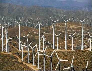
Wind Farm File Photo
Pilots in the region are not opposed to windmills per se, they
simply don't want them on top of a mountain that close to the
primary ILS approach they use most often. Flight instructor and
Pilots Club member Gordon Ewald told the paper "The wind turbines
aren't the problem. It's where they want to put them. I certainty
want wind turbines, but not sticking into the airspace pilots have
to occupy when the weather is most challenging."
FAA review of Invenergy's request is expected to take several
months.
More News
Ultrahigh Frequency (UHF) The frequency band between 300 and 3,000 MHz. The bank of radio frequencies used for military air/ground voice communications. In some instances this may >[...]
During The 7 Second Descent, There Was Another TAWS Alert At Which Time The Engine Remained At Full Power On October 24, 2025 at 2115 mountain daylight time, a Cirrus SR22T, N740TS>[...]
From 2009 (YouTube Edition): Educational Organization Aims to Inspire by Sharing Tuskegee Story Founding leader Don Hinz summarized the Red Tail Project’s mission in simple, >[...]
“This feels like an important step since space travel for people with disabilities is still in its very early days... I’m so thankful and hope it inspires a change in m>[...]
Also: New Katanas, Kern County FD Training, IndiGo’s Botched Roster, MGen. Leavitt Named ERAU Dean The Australian Transportation Safety Bureau (ATSB) has wrapped up its inves>[...]
 ANN's Daily Aero-Term (12.19.25): Ultrahigh Frequency (UHF)

