Drone Suspected In Wildfire In Arizona | Aero-News Network
Aero-News Network
RSS icon RSS feed
podcast icon MP3 podcast
Subscribe Aero-News e-mail Newsletter Subscribe

Airborne Unlimited -- Most Recent Daily Episodes

Episode Date

Airborne-Monday

Airborne-Tuesday

Airborne-Wednesday Airborne-Thursday

Airborne-Friday

Airborne On YouTube

Airborne-Unlimited-07.07.25

Airborne-NextGen-07.08.25

AirborneUnlimited-07.09.25

Airborne-FlightTraining-07.10.25

AirborneUnlimited-07.11.25

Mon, Mar 12, 2018

Drone Suspected In Wildfire In Arizona

About 30 Firefighters Contained The Blaze That Burned 335 Acres

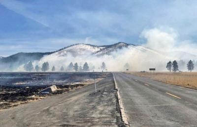
A drone is considered the culprit in a wildfire that burned some 335 acres near Kendrick Park in the Coconino National Forest near Flagstaff, AZ.

The U.S. Forest Service said in a news release that at approximately 12:35 p.m. local time last Tuesday, several firefighter crews responded to a smoke report from a drone in an area north of Flagstaff. The response included several Forest Service engines, patrols, and a water tender truck dispatched from the Summit fire department.

Overall, the fire burned 335-acres of forest land before the forward progress was stopped that afternoon.

Approximately 30 firefighters worked in the grasslands to stop the progress of this wildfire. The Chapel of the Holy Dove was in the area of the wildfire, but firefighting crews were able to protect the building by using fire to burn the fuels between the spreading wildfire and the Chapel. The backburning successfully kept damaging heat and flames away from the Chapel.

Several Forest Service engines, patrols and a water tender truck from Summit Fire responded to a smoke report from a drone on fire north of Flagstaff at approximately 12:35. The fire began near Forest Road 514 & FR 524 intersection by a drone which caught fire upon landing. The fire was reported as 50-acres in size upon the firefighter’s arrival.

Coconino National Forest spokesman George Jozens said authorities are still attempting to identify the type of drone, and who was operating the aircraft at the time on the incident.

(U.S. Forest Service image)

FMI: www.fs.usda.gov

Advertisement

More News

NTSB Final Report: Aviat A1

Airplane Bounced About 3 Ft Then Touched Back Down And Then, With No Brakes Applied, The Airplane Began Veering To The Left Analysis: The pilot entered the airport traffic pattern >[...]

ANN's Daily Aero-Linx (07.08.25)

Aero Linx: British Microlight Aircraft Association (BMAA) The primary focus within all aviation activity is SAFETY. In all aspects of our sport SAFETY must come first, whether it b>[...]

Classic Aero-TV: Fly Corvair’s Reliable Engine Alternative

From SnF25 (YouTube Edition): William Wynne Builds Practical Aircraft Engines on the Corvair Platform Seeking an affordable alternative to the traditional aircraft engine options, >[...]

ANN FAQ: Contributing To Aero-TV

How To Get A Story On Aero-TV News/Feature Programming How do I submit a story idea or lead to Aero-TV? If you would like to submit a story idea or lead, please contact Jim Campbel>[...]

Classic Aero-TV: CiES Fuel-Quantity and e-Throttle Systems Praised

From 2023 (YouTube Edition): Bridge of CiES CiES Inc. is a Bend, Oregon-based designer and manufacturer of modular embedded aircraft systems and sensors. The company’s fuel-l>[...]

blog comments powered by Disqus


Advertisement

Advertisement

Podcasts

Advertisement

© 2007 - 2025 Web Development & Design by Pauli Systems, LC