Thu, Oct 30, 2014
Over 57,000 Square Miles Mapped And Analyzed
The Australian government says that it is progressing in its search for Malaysian Airlines Flight 370, a Boeing 777 that vanished in March of this year.
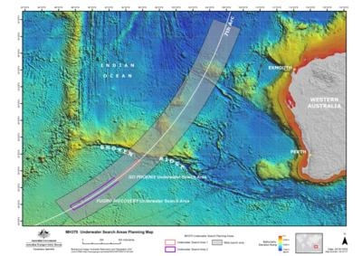
The search team, led by the Australian Transport Safety Bureau (ATSB), says it has mapped and analyzed over 150,000 square kilometers (approx. 57,000 sq miles) ... which it says is "sufficient area having been surveyed for the underwater search to take place." According to the update, the sea floor in the search area had never previously been mapped in detail. Before the sidescan sonar work to locate MH370 could begin, it was necessary to conduct a bathymetric survey to ensure that the equipment could be operated safely. The survey vessel Fugro Equator and the Chinese survey vessel Zhu Khezhen collaborated on survey operations, until Zhu Khezhen completed her assignment on September 20 and returned to China.
The ATSB says that while it is impossible to determine with certainty where the aircraft may have entered the water, the available data and analysis indicate that the most likely location lies close to a long but narrow arc in the southern Indian Ocean (where the aircraft last communicated with a ground station through a satellite). This is where the aircraft is assessed to have run out of fuel. Complex and ground-breaking technical analysis of the limited satellite communications data and aircraft flight information has been developed and refined since the disappearance of MH370. That work has concentrated on determining the area on the seventh arc that the aircraft was most likely to have reached, enabling a prioritized search effort.
After mapping, the ATSB says that Over 2,500 square kilometres (approx 965 sq miles) of the sea floor have been searched so far.
In addition to locating the aircraft, the underwater search aims to identify any crucial evidence (such as aircraft wreckage and flight recorders) to assist with the Malaysian investigation. The ATSB has utilized the data from the bathymetric survey work to prepare the initial plan for the underwater search, to be followed and referred to by all parties involved. The plan includes search timings, methods, procedures, safety precautions and search areas. The initial search areas have been allocated to the different vessels with the aim of positively identifying and mapping the debris field of MH370.
(ATSB Image)
More News
Also: Centauri Aircraft Valkyrie, Meet the Admin, Night Airshow, Pelton Intv'w When we laid eyes on this critter, we fell in love… and then we learned the amazing story of t>[...]
Check out Blackshape in Oshkosh Display #190 Situated in the Apulian Aerospace district in Monopoli, Italy, Blackshape embodies the epitome of Italian craftsmanship, style, and qua>[...]
A Powerhouse In Aviation Safety Technology, Visit Alpha Systems AOA at Osh Display#3124-3125 Alpha systems AOA has been developing and integrating Angle of Attack systems for the l>[...]
High-Flying Models By PilotMall.com: Honoring Aviation's Legacy We are dedicated to preserving and celebrating our rich aviation heritage through stunning mahogany wood scale repli>[...]
CiES Has Pioneered Life Saving Technology Of Use To Pilots All Over The World... Booth 3119 CiES: CiES Inc. is the global leader in digital fuel quantity sensors for general aviati>[...]
 OSH25 Day Four Redux: Spirit SE-1!, H55 eFlyer, King Schools