UAVOS And Polynesian Exploration Creating Autonomous Solution For 3D Mapping | Aero-News Network
Aero-News Network
RSS icon RSS feed
podcast icon MP3 podcast
Subscribe Aero-News e-mail Newsletter Subscribe

Airborne Unlimited -- Most Recent Daily Episodes

Episode Date

Airborne-Monday

Airborne-Tuesday

Airborne-Wednesday Airborne-Thursday

Airborne-Friday

Airborne On YouTube

Airborne-Unlimited-05.20.24

Airborne-Unlimited-05.28.24

Airborne-FlightTraining-05.29.24 Airborne-Unlimited-05.30.24

Airborne-Unlimited-05.24.24

Thu, Nov 07, 2019

UAVOS And Polynesian Exploration Creating Autonomous Solution For 3D Mapping

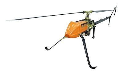
Deployed On A UVH -25EL Unmanned Helicopter

UAVOS Inc, in conjunction with the maker of the POLYSCANNER Aerial 3D Mapping and Surveying system Polynesian Navigation, Inc., has announced a partnership to provide a long-distance autonomous solution for 3D mapping.

The light unmanned helicopter UVH -25EL powered by UAVOS's autopilot is an ideal platform for a long-distance autonomous solution for 3D mapping. The UVH-25EL has increased performance with a carrying capacity, a flying range, and an extended temperature range. Take-off and landing as well as missions are carried out automatically.

The POLYSCANNER is an integrated payload solution for Aerial HD Mapping and Surveying. The system features a choice of LiDAR’s, a global shutter camera and dual frequency RTK GNSS/INS with centimeter-level accuracy, as well as a high level of integration and sensor fusion software. The system is capable of creating accurate colorized 3D models in a point cloud format.

“We have been extending into UAV service market to meet its goal of offering state-of-the-art systems that are easy to use and offer excellent cost/performance value to our customers,” said UAVOS CEO Aliaksei Stratsilatau.

(Image provided with UAVOS news release)

FMI: www.uavos.com

Advertisement

More News

ANN FAQ: Contributing To Aero-TV

How To Get A Story On Aero-TV News/Feature Programming How do I submit a story idea or lead to Aero-TV? If you would like to submit a story idea or lead, please contact Jim Campbel>[...]

ANN's Daily Aero-Linx (05.29.24)

Aero Linx: International Association of Professional Gyroplane Training (IAPGT) We are an Association of people who fly, build or regulate Gyroplanes, who have a dream of a single >[...]

ANN's Daily Aero-Term (05.29.24): NORDO (No Radio)

NORDO (No Radio) Aircraft that cannot or do not communicate by radio when radio communication is required are referred to as “NORDO.”>[...]

Airborne 05.28.24: Jump Plane Down, Starship's 4th, Vision Jet Problems

Also: uAvionix AV-Link, F-16 Viper Demo, TN National Guard, 'Staff the Towers' A Saturday afternoon jump run, originating from SkyDive Kansas City, went bad when it was reported th>[...]

ANN's Daily Aero-Term (05.30.24): Beyond Visual Line Of Sight (BVLOS)

Beyond Visual Line Of Sight (BVLOS) The operation of a UAS beyond the visual capability of the flight crew members (i.e., remote pilot in command [RPIC], the person manipulating th>[...]

blog comments powered by Disqus


Advertisement

Advertisement

Podcasts

Advertisement

© 2007 - 2024 Web Development & Design by Pauli Systems, LC