Parrot UAS Releases 4G-LTE Long-Range Drone | Aero-News Network
Aero-News Network
RSS icon RSS feed
podcast icon MP3 podcast
Subscribe Aero-News e-mail Newsletter Subscribe

Airborne Unlimited -- Most Recent Daily Episodes

Episode Date

Airborne-Monday

Airborne-Tuesday

Airborne-Wednesday Airborne-Thursday

Airborne-Friday

Airborne On YouTube

Airborne-Unlimited-05.19.25

Airborne-NextGen-05.20.25

AirborneUnlimited-05.21.25

Airborne-AffordableFlyers-05.22.25

AirborneUnlimited-05.23.25

Fri, Dec 10, 2021

Parrot UAS Releases 4G-LTE Long-Range Drone

Autonomous, Enterprise-Level Anafi Ai To Ship in Jan 2022

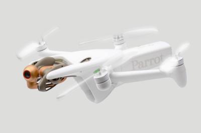
Parrot has announced a new version of its ANAFI drone, the 4G LTE-connected enterprise platform, Anafi Ai. Equipped with an HDR10, 48 megapixel camera suite, sensor survey capability, single-click photogrammetry, onboard drone SDK, fully autonomous capability, the drone adds a much longer ranged option to the Parrot portfolio.

Using ubiquitous Verizon LTE networking, the Ai can fly unrestrained by direct line of sight and wi-fi networks, enabling a wider range of targets to be surveyed. 

The Anafi Ai is far and away beyond the average, consumer-grade drone, offering an open source on-aircraft SDK for onboard coding capabilities, FIPS140-2 compliant design, and open source software. The Anafi joins the world's largest drone ecosystem, taking everything that made the previous models so successful and creating a cellular-enabled, beyond-line-of-sight capable UAV. Compatible with 4G networks around the world, the drone can connect without a range limit to complete any mission. In the demonstration, the Ai was able to map difficult targets including large, seaside buildings, sprawling metro areas with dense ground level obstruction, and tall cell towers with impressive accuracy.  

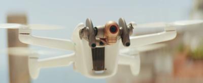
The drone's distinctive image capture equipment lies atop an insectoid derived gimbal, with the mounts capable of 3-axis orientation, yaw, pitch and roll. Conventional, traditional drones restrict their movement on 2 axes, a swiveling and tilting base. The 48 mp camera can film at 4K resolution at 60 frames per second, with full support for real time HDR10 capture, 14 EV dynamic range, and a 6x zoom capability. At 240 feet, the camera is capable of finding details at 1 centimeter. The 1/2 inch CMOS sensor may be small for a handheld professional camera, but its size is plenty on a flyweight airborne drone.  

The specs may not be ground breaking or boundary pushing, but the Anafi is a workhorse, not an art student. Its cameras are good enough for what it was bred for: fully autonomous photogrammetry. Shooting at its full 48mp at 1 fps, it can attain survey accuracy of 0.46 centimeter per pixel GSD at 100 feet. Mission planners will enjoy the easy, embedded PIX4D flight planning integration, as well as the 4G uplink to transfer its data over the network. 

The Anafi Ai is available for preorder, but enterprise-level performance comes at an enterprise-worthy price. $/€ 4,000 will see the Anafi Ai inbound to customers in January 2022. 

FMI: www.parrot.com

Advertisement

More News

Oshkosh Memories: An Aero-News Stringer Perspective

From 2021: The Inside Skinny On What Being An ANN Oshkosh Stringer Is All About By ANN Senior Stringer Extraordinare, Gene Yarbrough The annual gathering at Oshkosh is a right of p>[...]

NTSB Prelim: Piper PA32RT

Video Showed That During The Takeoff, The Nose Baggage Door Was Open On May 10, 2025, about 0935 eastern daylight time, a Piper PA-32RT-300, N30689, was destroyed when it was invol>[...]

ANN FAQ: Follow Us On Instagram!

Get The Latest in Aviation News NOW on Instagram Are you on Instagram yet? It's been around for a few years, quietly picking up traction mostly thanks to everybody's new obsession >[...]

Aero-News: Quote of the Day (05.28.25)

"I think what is key, we have offered a bonus to air traffic controllers who are eligible to retire. We are going to pay them a 20% bonus on their salary to stay longer. Don't reti>[...]

ANN's Daily Aero-Term (05.28.25): Pilot Briefing

Aero Linx: Pilot Briefing The gathering, translation, interpretation, and summarization of weather and aeronautical information into a form usable by the pilot or flight supervisor>[...]

blog comments powered by Disqus


Advertisement

Advertisement

Podcasts

Advertisement

© 2007 - 2025 Web Development & Design by Pauli Systems, LC