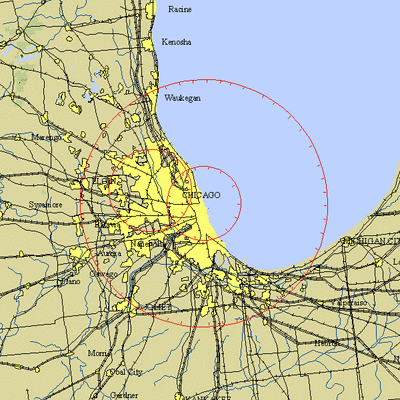
 NOTAM Number: FDC 8/0204
Issue Date: January 03, 2008 at 1735 UTC
Location: Chicago, Illinois
Beginning Date and Time: January 07, 2008 at 1505 UTC
Ending Date and Time: January 07, 2008 at 2100 UTC
Reason for NOTAM: Temporary flight restrictions for VIP (Very
Important Person) Movement
Type: VIP
Replaced NOTAM(s): N/A
Affected Area(s)
Area A
Airspace Definition:
Center: On the CHICAGO O'HARE VOR/DME (ORD) 107 degree
radial at 13.3 nautical miles. (Latitude: 41º54'56"N,
Longitude: 87º37'22"W)
Radius: 30 nautical miles
Altitude: From the surface up to but not including
FL(180)
Effective Date(s):
From January 07, 2008 at 1505 UTC (January 07, 2008 at 0905
CST)
To January 07, 2008 at 2100 UTC (January 07, 2008 at 1500
CST)
Area B
Airspace Definition:
Center: CHICAGO O'HARE VOR/DME(ORD) (Latitude:
41º59'16"N, Longitude: 87º54'18"W)
Radius: 10 nautical miles
Altitude: From the surface up to but not including
FL(180)
Effective Date(s):
From January 07, 2008 at 1505 UTC (January 07, 2008 at 0905
CST)
To January 07, 2008 at 1610 UTC (January 07, 2008 at 1010
CST)
Area C
Airspace Definition:
Center: On the CHICAGO O'HARE VOR/DME (ORD) 107 degree radial
at 13.3 nautical miles. (Latitude: 41º54'56"N, Longitude:
87º37'22"W)
Radius: 9 nautical miles
Altitude: From the surface up to but not including
FL(180)
Effective Date(s):
From January 07, 2008 at 1525 UTC (January 07, 2008 at 0925
CST)
To January 07, 2008 at 2030 UTC (January 07, 2008 at 1430
CST)
Area D
Airspace Definition:
Center: CHICAGO O'HARE VOR/DME(ORD) (Latitude:
41º59'16"N, Longitude: 87º54'18"W)
Radius: 10 nautical miles
Altitude: From the surface up to but not including
FL(180)
Effective Date(s):
From January 07, 2008 at 1955 UTC (January 07, 2008 at 1355
CST)
To January 07, 2008 at 2100 UTC (January 07, 2008 at 1500
CST)

Operating Restrictions and Requirements
No pilots may operate an aircraft in the areas covered by this
NOTAM (except as described).
Except as specified below and/or unless authorized by the air
traffic security coordinator via the Domestic Events Network
(DEN):
A. All aircraft operations within the 9/10 NMR area listed above
are prohibited except for:
Approved law enforcement, military aircraft directly supporting
the United States Secret Service (USSS) and the Office of the
President of the United States, approved emergency medical flights,
and regularly scheduled commercial passenger and all-cargo carriers
operating under one of the following TSA-Approved standard security
programs/procedures: aircraft operator standard security program
(AOSSP), domestic security integration program (DSIP), twelve five
standard security program (TFSSP) all cargo, or all-cargo
international security procedure (ACISP) and are arriving into
and/or departing from 14 CFR part 139 airports.
For operations within the TFR, all emergency/life saving flight
(medical/law enforcement/firefighting) operations must coordinate
in advance with the USSS at 847-608-5654 to avoid potential
delays.
B. Within the airspace between 9/10 NMR and 30 NMR listed
above:
All aircraft entering or exiting the 30 NMR TFR must be on an
active IFR or VFR flight plan with a discrete code assigned by an
Air Traffic Control (ATC) facility. Aircraft must be squawking the
discrete code prior to departure and at all times while in the
TFR.
All aircraft entering or exiting the 30 NMR TFR must remain in
two-way radio communications with ATC.
All aircraft operating within the 9/10 to 30 NMR TFR and
operating at altitudes of up to but not including FL180 are limited
to aircraft arriving or departing local airfields and ATC may
authorize transit operations. Aircraft may not loiter.
Flight training, practice instrument approaches, aerobatic
flight, glider operations, parachute operations, ultralight, hang
gliding, balloon operations, agriculture/crop dusting, animal
population control flight operations, banner towing operations,
model aircraft operations, model rocketry, and unmanned aerial
systems (UAS) are not authorized.
All USSS cleared aircraft operators based in the area should
notify the USSS prior to their departure.
For operations within the TFR, all emergency/life saving flight
(medical/law enforcement/firefighting) operations must coordinate
in advance with the USSS at 847-608-5654 to avoid potential
delays.
C. FAA recommends that all aircraft operators check NOTAMS
frequently for possible changes to this TFR prior to operations
within this region.
Other Information:
ARTCC: ZAU - Chicago Center
Authority: Title 14 CFR section 91.141
FMI: www.tfr.faa.gov,
Depicted TFR data may not be a complete listing. Pilots should not
use the information on this website for flight planning purposes.
For the latest information, call your local Flight Service Station
at 1-800-WX-BRIEF.
 Aero-News: Quote of the Day (11.27.25)
 Airborne 11.26.25: Bonanza-Baron Fini, Archer v LA NIMBYs, Gogo Loses$$$
 FAA Seeks Info For New Brand-New ATC Platform
 USAF Reaper Drone Crashes Off the South Korean Coast
 Hartzell Engine Tech Magneto Gains FAA-PMA


