Aero-Tips!
A good pilot is always learning -- how many times have you
heard this old standard throughout your flying career? There is no
truer statement in all of flying (well, with the possible exception
of "there are no old, bold pilots.")

Aero-News has called upon the expertise of Thomas P. Turner,
master CFI and all-around-good-guy, to bring our readers -- and us
-- daily tips to improve our skills as aviators. Some of them, you
may have heard before... but for each of us, there will also be
something we might never have considered before, or something that
didn't "stick" the way it should have the first time we memorized
it for the practical test.
Look for our daily Aero-Tips segments, coming each day to
you through the Aero-News Network.
Aero-Tips 07.17.06
It's hot and humid -- will thunderstorms pop up?
I've scheduled to fly from Wichita to Fayetteville, Arkansas
this evening. It was a warm and muggy morning, perfect for air mass
thunderstorms in the afternoon. It's now 3 pm and the sky's still
untainted blue... so what will it be like around 7 pm?
The Lifted Index (LI) is a measurement of atmospheric stability.
Positive numbers indicate positive stability, i.e., air tends to
remain stable and lifting action dampens itself out. A "0" LI means
a neutrally stable atmosphere, so localized sources of lifting
action (mountains, rising heat in very hot areas) may continue to
build, but others may dampen themselves out. If the LI is negative
the atmosphere is unstable, so any localized lifting action is
enhanced. If unstable air is also moist, towering cumulus and
thunderstorms are likely. Areas of a LI of -4 or lower often
generate severe thunderstorms.

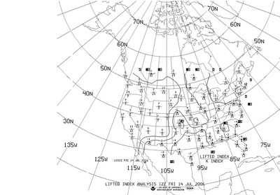
This morning's (7 am local) Lifted Analysis chart is shown above.
At each reporting point, the LI is the upper of a pair of numbers
separated by a line-looking like the numerator of a fraction.
Notice in eastern Kansas and extreme northwestern Arkansas, where
I'll be flying, the LI is positive-chances are I won't see any
thunderstorm build-ups this evening.
While we're at it, look at the areas where negative LIs
appear-central Kansas, Texas through extreme southern Arizona and
New Mexico, and in a large but fairly distinct area defined by
about the Mississippi River on the west through a Detroit to
Washington DC line and just about everything south and east of
there.

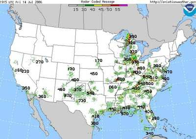
Now look at the radar picture above, valid at 2:15 pm
local on the same day. There's that pocket of storms in west
Kansas, mountainous areas of Arizona and New Mexico, large areas in
Texas (including one cell with radar tops to 73,000 feet), and
almost everywhere inside the defined area in the east.
Notably, see how my east Kansas-NW Arkansas route remains clear,
and how distinctly the storm area ends north and east of the
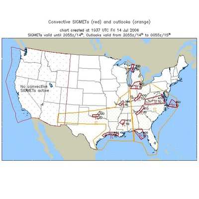
Detroit-DC line. The 2:37 pm local Convective SIGMETs and
forecasts (below) closely follow the LI lines as
well.

With this morning's Lifted Index information being accurately
reflected in this afternoon's weather, there's a very good chance
I'll make tonight's trip without having to deal with
thunderstorms.
Aero-tip of the day: A quick look at the Lifted
Index helps you make a strategic plan for dealing with
thunderstorms later in the day.
 NTSB Final Report: Rutan Long-EZ
 ANN FAQ: Turn On Post Notifications
 Classic Aero-TV: ICAS Perspectives - Advice for New Air Show Performers
 ANN's Daily Aero-Linx (06.28.25)
 Aero-News: Quote of the Day (06.28.25)

