Improvements To Benefit Students, Experienced Pilots Alike
Though somewhat overshadowed by Garmin's BIG news regarding
synthetic vision, that wasn't the only news the company had to
share in the moments leading up to Lakeland 2008. The avionics
manufacturer also announced Monday enhancements to the GMX 200
multi-function display (MFD,) giving pilots the benefit of Garmin
FliteCharts and Garmin SafeTaxi.
These new database offerings greatly enhance situational
awareness during taxiing and simplify the availability of
procedural information during all phases of pilot operations.
FliteCharts and SafeTaxi will be featured at Garmin's both at
Lakeland.
Garmin FliteCharts is an electronic version of the National
Aeronautical Chart Office (NACO) US Terminal Procedures
Publication. FliteCharts lets pilots quickly find and view all NACO
Departure Procedures (DP), Standard Terminal Arrival Routes
(STARs), approach charts, and airport diagrams on the MFD. GMX
200’s equipped with FliteCharts will have access to all U.S.
approach plates currently published by NACO, which includes 14,000
approach plates at over 2,900 airports. FliteChart are not
geo-referenced and updates are offered every
28-days.
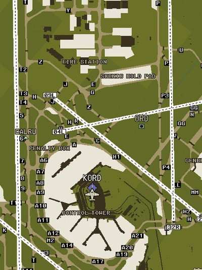
 Thanks to Garmin SafeTaxi, GMX 200
owners can taxi around unfamiliar airports with ease. SafeTaxi
identifies runways, taxiways, FBOs, hangars, and the
aircraft’s exact location on the field. The SafeTaxi
information is seamlessly integrated with GMX 200’s existing
basemap at the appropriate map range setting, and SafeTaxi details
increase as the range setting decreases. Since SafeTaxi is
geo-referenced, pilots will benefit by seeing their aircraft icon
move precisely along the taxiway diagram. SafeTaxi includes over
850 US airports and diagrams, and Garmin continues to develop and
offer new airport charts as additional data becomes available.
SafeTaxi updates are available every 56-days.
Thanks to Garmin SafeTaxi, GMX 200
owners can taxi around unfamiliar airports with ease. SafeTaxi
identifies runways, taxiways, FBOs, hangars, and the
aircraft’s exact location on the field. The SafeTaxi
information is seamlessly integrated with GMX 200’s existing
basemap at the appropriate map range setting, and SafeTaxi details
increase as the range setting decreases. Since SafeTaxi is
geo-referenced, pilots will benefit by seeing their aircraft icon
move precisely along the taxiway diagram. SafeTaxi includes over
850 US airports and diagrams, and Garmin continues to develop and
offer new airport charts as additional data becomes available.
SafeTaxi updates are available every 56-days.
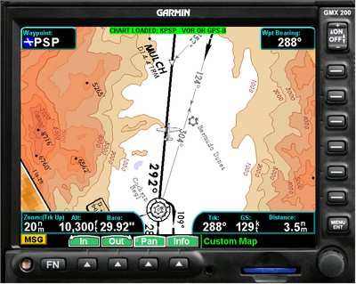
The GMX 200 is a popular MFD that is compatible with
Garmin’s GNS™ 400/500 series, GNS 480, GDL® 69/69A,
GTX™ 330/33, GDL 90, GWX 68, and many other
manufacturers’ GPS navigation equipment. The display is
almost 20-percent larger than other aftermarket panel mounted MFDs,
and it features advanced backlighting technology that vividly
displays colors and images in all lighting conditions. The GMX 200
displays the aircraft’s position relative to terrain,
obstructions, weather, airways, navaids, restricted airspace, and
more. The unit includes high resolution, worldwide terrain and
hydrography data. Map scales range from one-fourth of a mile to
2,500 miles, and a unique split screen function lets pilots
simultaneously view two charting options along with the vertical
profile for the elevation of the terrain ahead of the aircraft.
Garmin ChartView, which is powered by Jeppesen and features
geo-referenced approach charts, continues to be an option for all
GMX 200 operators.
Pilots purchasing a new GMX 200 between April and December 2008
will receive a recent version of FliteCharts and SafeTaxi preloaded
on the MFD at no additional cost. Existing GMX 200 customers can
add Garmin FliteCharts and SafeTaxi to their GMX 200 by purchasing
a SD datacard that is loaded via the GMX 200’s front loading
SD card-slot. This 2GB datacard includes FliteCharts and SafeTaxi.
The expected street price for the GMX 200’s FliteCharts and
SafeTaxi SD card is $695.
FliteCharts and SafeTaxi upgrades are available on a
single-cycle or annual basis. FliteCharts are $95 per update or
$395 annually (13 consecutive cycles) and SafeTaxi is $35 per
update or $195 annually (seven consecutive cycles).
 NTSB Final Report: Rutan Long-EZ