Tue, Sep 24, 2019
Included Classroom Instruction And Hands-On Flights
Oceans Unmanned, Inc., in partnership with DARTDrones, recently trained seven NOAA ship officers and Navigation Response Team members on drone operations at the NOAA Marine Operations Center in Newport, OR. The successful two-day training included classroom instruction and hands-on flights focused on vessel-based research and mapping missions. Students practiced launch and recovery procedures, and programmed mapping missions from the deck of the NOAA Ship Hi‘ialakai while alongside the marine facility. This training is the first step to more broadly integrating drone operations for a variety of missions across the NOAA fleet.
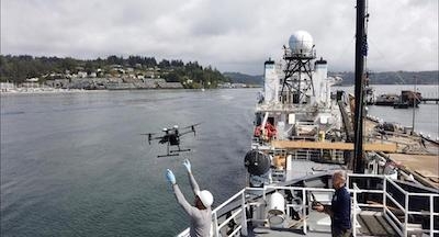
Students were trained and certified on the DJI Mavic and Phantom series, and introduced to the larger Matrice 210RTK drones. These systems have a proven, reliable track record for being user-friendly, and highly capable for ship and small boat launch and recovery. “We have multiple years of experience in vessel-based drone operations supporting missions including wildlife surveys, habitat mapping, shallow water shipwreck surveys, and more, and are excited to assist NOAA in utilizing these systems safely and efficiently.” said Brian Taggart, Chief Pilot of Oceans Unmanned. “These relatively inexpensive, off-the-shelf drones, have the capability to support a wide variety of ocean and coastal environmental research projects.”
NOAA is integrating small drones aboard their survey ships for near-shore and shoreline feature charting, by supporting or augmenting traditional shoreline verification and mapping techniques used by hydrographic survey field units. Potential benefits of using drones for this requirement include: improved data collection efficiency compared to data collection from small boats; more accurate feature investigation than traditional techniques; and, most importantly, removal of personnel from potentially dangerous situations.
The training was supported and funded by the NOAA National Geodetic Survey (NGS) Remote Sensing Division (RSD) which has been evaluating and operating drones for several years to meet coastal mapping requirements. “RSD has developed much of the internal policies, procedures, and protocols necessary for safe and effective drone field operations for mapping,” said Mike Aslaksen, Chief, NOAA Remote Sensing Division. “and we’re big supporters of getting this technology operational across the NOAA fleet.”
(Image provided with Oceans Unmanned news release)
More News
From 2014 (YouTube Version): One Of The Airshow World's Pre-Eminent Formation Teams Chats About The State Of The Industry At EAA AirVenture 2014, ANN News Editor Tom Patton gets th>[...]
Tactical Air Navigation (TACAN) An ultra-high frequency electronic rho-theta air navigation aid which provides suitably equipped aircraft a continuous indication of bearing and dis>[...]
Aero Linx: Doobert Hi, we're Chris & Rachael Roy, founders and owners of Doobert. Chris is a technology guy in his “day” job and used his experience to create Doobe>[...]
The Airplane Was Spinning In A Nose-Down Attitude Before It Impacted Terrain On June 20, 2025, at 0900 eastern daylight time, a Pitts Aerobatics S-2B, N79AV, was destroyed when it >[...]
Also: United Elite Sues, Newark ATC Transitions, Discovery Moves?, Textron @ KOSH The Commemorative Air Force Airbase Arizona is taking its “Flying Legends of Victory Tour&rd>[...]
 Classic Aero-TV: Up Close And Personal - The Aeroshell Aerobatic Team at Oshkosh