NASA's MRO Sees Pathfinder Landing Site | Aero-News Network
Aero-News Network
RSS icon RSS feed
podcast icon MP3 podcast
Subscribe Aero-News e-mail Newsletter Subscribe

Airborne Unlimited -- Most Recent Daily Episodes

Episode Date

Airborne-Monday

Airborne-Tuesday

Airborne-Wednesday Airborne-Thursday

Airborne-Friday

Airborne On YouTube

Airborne-Unlimited-06.23.25

Airborne-NextGen-06.24.25

AirborneUnlimited-06.25.25

Airborne-AffordableFlyers-06.26.25

AirborneUnlimited-06.27.25

Sun, Jan 14, 2007

NASA's MRO Sees Pathfinder Landing Site

Newest Probe Sees Evidence Of Predecessor

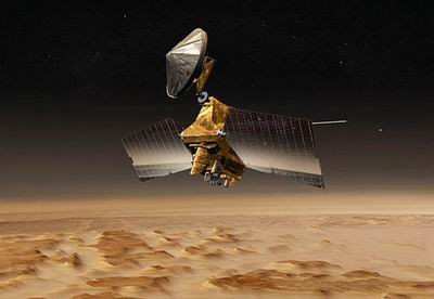
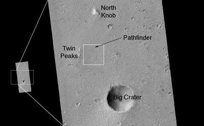
The high-resolution camera on NASA's Mars Reconnaissance Orbiter has captured images the 1997 landing site of NASA's Mars Pathfinder, revealing new details of hardware on the surface and the geology of the region.

The Pathfinder mission's small rover, Sojourner, appears to have moved closer to the stationary lander after the final data transmission from the lander, based on tentative identification of the rover in the image. Pathfinder landed on July 4, 1997, and transmitted data for 12 weeks. Unlike the two larger rovers, Spirit and Opportunity, currently active on Mars, Sojourner could communicate only with the lander, not directly with Earth.

The lander's ramps, science deck and portions of the airbags can be discerned in the new image. The parachute and backshell used in the spacecraft's descent lie to the south, behind a hill from the viewpoint of the lander. Four bright features may be portions of the heat shield.

Rob Manning, Mars program chief engineer at NASA's Jet Propulsion Laboratory, Pasadena, said, "The new image provides information about Pathfinder's landing and should help confirm our reconstruction of the descent as well as give us insights into the landing and the airbag bounces."

Dr. Alfred McEwen of the University of Arizona, Tucson, principal investigator for the High Resolution Imaging Science Experiment, said "Pathfinder's landing site is one of the most-studied places on Mars. Making connections between this new orbital image and the geological information collected at ground level aids our interpretation of orbital images of other places."

The Mars Reconnaissance Orbiter is managed by JPL for NASA's Science Mission Directorate, Washington, DC.

(Photos courtesy of NASA)

FMI: www.nasa.gov/mro

Advertisement

More News

ANN's Daily Aero-Linx (06.29.25)

Aero Linx: Transport Canada We are a federal institution, leading the Transport Canada portfolio and working with our partners. Transport Canada is responsible for transportation p>[...]

ANN's Daily Aero-Term (06.29.25): Gross Navigation Error (GNE)

Gross Navigation Error (GNE) A lateral deviation from a cleared track, normally in excess of 25 Nautical Miles (NM). More stringent standards (for example, 10NM in some parts of th>[...]

Classic Aero-TV: Anticipating Futurespace - Blue Origin Visits Airventure 2017

From AirVenture 2017 (YouTube Edition): Flight-Proven Booster On Display At AirVenture… EAA AirVenture Oshkosh is known primarily as a celebration of experimental and amateu>[...]

NTSB Final Report: Cirrus SR22

Aircraft Parachute System (CAPS) Was Deployed About 293 Ft Above Ground Level, Which Was Too Low To Allow For Full Deployment Of The Parachute System Analysis: The day before the a>[...]

Airborne Affordable Flyers 06.26.25: PA18 Upgrades, ‘Delta Force’, Rhinebeck

Also: 48th Annual Air Race Classic, Hot Air Balloon Fire, FAA v Banning 100LL, Complete Remote Pilot The news Piper PA-18 Super Cub owners have been waiting for has finally arrived>[...]

blog comments powered by Disqus


Advertisement

Advertisement

Podcasts

Advertisement

© 2007 - 2025 Web Development & Design by Pauli Systems, LC