South Dakota Team Explores UAVs To Monitor Road Safety | Aero-News Network
Aero-News Network
RSS icon RSS feed
podcast icon MP3 podcast
Subscribe Aero-News e-mail Newsletter Subscribe

Airborne Unlimited -- Most Recent Daily Episodes

Episode Date

Airborne-Monday

Airborne-Tuesday

Airborne-Wednesday Airborne-Thursday

Airborne-Friday

Airborne On YouTube

Airborne-Unlimited-09.15.25

AirborneNextGen-
09.09.25

Airborne-Unlimited-09.10.25

Airborne-AffordableFlyers-09.11.25

AirborneUnlimited-09.12.25

Thu, Nov 15, 2007

South Dakota Team Explores UAVs To Monitor Road Safety

Cheaper Costs Leading To More Applications Of Technology

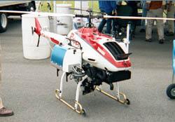
Here's a story about just how quickly prices for unmanned aircraft are coming down. A scientist at South Dakota State University has won a federal grant to continue his studies of unmanned helicopters for safety inspections of dirt roads.

Until recently, UAVs and their tiny cameras cost so much that only the military could afford them... but those prices are dropping, as the unmanned vehicles gain in popularity in a growing number of applications.

Dave Huft, research manager at the South Dakota Department of Transportation, tells the Argus Leader they have become much cheaper and faster than sending out guys with hard hats and tape measures to find roads that are too narrow, banked in such a way to make curves unsafe, or otherwise substandard.

"It's making such a difference in the speed of the measurement that it's going from something that was not practical, or impossible, to something that is practical," Huft said.

Even a low-resolution image captured by a UAV could be used by a computer "trained" to recognize road damage, according to a team led by Chunsun Zhang, a remote sensing scientist at SDSU.

There are, of course, downsides to using UAVs to patrol roads.

Pilots of manned aircraft are obviously concerned, of course... but this could also be a real threat to those guys in hard hats. After all... unmanned helicopters don't require anyone to lean on a shovel.

FMI: www.sdstate.edu, www.sddot.com/

Advertisement

More News

NTSB Prelim: Lancair NLA-275-FR-C

About 2132 And At 11,800 Ft MSL, The Airplane Began A Rapid Right Spiraling Descent On August 18, 2025, about 2133 central daylight time, a Lancair NLA-275-FR-C airplane, N345LA, w>[...]

ANN's Daily Aero-Linx (09.12.25)

Aero Linx: The Collings Foundation The Collings Foundation is a non-profit, Educational Foundation (501(c)3), founded in 1979. The purpose of the Foundation is to preserve and exhi>[...]

Aero-News: Quote of the Day (09.12.25)

"This first FAA certification enables us to address the pilot shortage crisis with modern training solutions. Flight schools need alternatives to aging fleets with 40-year-old desi>[...]

ANN's Daily Aero-Term (09.12.25): North Atlantic High Level Airspace (NAT HLA)

North Atlantic High Level Airspace (NAT HLA) That volume of airspace (as defined in ICAO Document 7030) between FL 285 and FL 420 within the Oceanic Control Areas of Bodo Oceanic, >[...]

Aero-News: Quote of the Day (09.13.25)

“HITRON embodies the Coast Guard’s spirit of innovation and adaptability. From its humble beginnings as a prototype program, it has evolved into a vital force in our co>[...]

blog comments powered by Disqus


Advertisement

Advertisement

Podcasts

Advertisement

© 2007 - 2025 Web Development & Design by Pauli Systems, LC