G500H All-Glass, Helicopter-Specific PFD And MFD
 Garmin International Inc took the wraps off the G500H on
Thursday afternoon, an all-glass avionics system designed
specifically for the VFR Part 27 helicopter market. The G500H is a
derivative of the G600 and G500 for the fixed-wing market, yet the
G500H has been optimized for rotorcraft and offers features like
helicopter synthetic vision technology (HSVT), helicopter-specific
databases with over 7,000 heliports and nearly 30,000 additional
low-altitude obstacles, XM WX Satellite Weather with NEXRAD, and
the ability to display video from a forward looking infrared (FLIR)
camera or other video sources.
Garmin International Inc took the wraps off the G500H on
Thursday afternoon, an all-glass avionics system designed
specifically for the VFR Part 27 helicopter market. The G500H is a
derivative of the G600 and G500 for the fixed-wing market, yet the
G500H has been optimized for rotorcraft and offers features like
helicopter synthetic vision technology (HSVT), helicopter-specific
databases with over 7,000 heliports and nearly 30,000 additional
low-altitude obstacles, XM WX Satellite Weather with NEXRAD, and
the ability to display video from a forward looking infrared (FLIR)
camera or other video sources.
"FAA reports have indicated that the three main areas of
operational risks for helicopters are inadvertent flight into IMC,
night operations and controlled flight into terrain," said Gary
Kelley, Garmin's vice president of marketing. "The G500H was
designed to proactively address these issues and help reduce
situational risk and the challenges that come from a busier
airspace. We're serious about safety and we believe our new
helicopter products will help make flying safer."
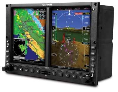
The bezel framing the G500H's primary flight display (PFD) and
multi-function display (MFD) (10"w x 6.7"h) allows for easy
installation into the instrument panel. The G500H system includes a
solid state Attitude and Heading Reference System (AHRS) for
superior reliability and accuracy. Garmin's AHRS features rapid
alignment while moving, including in-flight dynamic restarts.
The G500H is available in two versions - one with the PFD on the
right, the other version with the PFD on the left - allowing
maximum installation versatility. The PFD screen displays attitude,
airspeed, vertical speed, altitude and course/heading information,
and the MFD shows detailed moving map graphics with the
helicopter's current position in relation to terrain, chart data,
navaids, and flight plan routings.
The G500H communicates and integrates with Garmin's other panel
mount products, such as the GNS 430W/530W series. In addition to
the intrinsic benefits of WAAS approaches, Garmin has also
developed a special helicopter navigation database that lets
operators easily navigate to over 7,000 heliports, without having
to create user waypoints at those locations.
The G500H also supports Garmin's helicopter-specific synthetic
vision technology (HSVT). By adding Garmin's HSVT to the G500H, the
PFD will display an "out-the-window" view of the surroundings,
regardless of the weather conditions. HSVT seamlessly blends
information about the rotorcraft's position with topographic
databases to create and display real-time 3D images. Land, water
and sky are clearly differentiated with shading and textures that
are similar to the topographical colors found on the MFD moving
map. HSVT alerts pilots of potential ground hazards by displaying
terrain and obstacles which pose a threat to the aircraft.
Recognizing the importance of keeping track of personnel and
mobile assets, the G500H is also compatible with Garmin's new GSR
56 Iridium transceiver, an affordable worldwide position tracking
solution that enables aircraft location data to be monitored via
web-based displays on authorized base-ops computers. The Iridium
network provides seamless global coverage and enables the GSR 56 to
transmit a helicopter's position and flight track from anywhere in
the world.
Near real-time weather is also available as an option via XM WX
Satellite Weather (U.S. and Canada only) and Garmin's GDL 69.
Customers who equip their helicopter with the GDL 69 will receive
graphical weather depictions of NEXRAD, METARs, TAFs, TFRs, winds
aloft, echo tops, precipitation type at the surface, lightning
strikes, storm-cell data, AIRMETs, and SIGMETs. The weather data
may be laid directly over navigation and topographic map databases.
With the optional GDL 69A, pilots will also have access to more
than 170 channels of XM audio. Weather and music requires an XM
subscription.
Customers may interface the G500H with Garmin's TAS and TCAS I
traffic systems, the GTS 800, GTS 820 and GTS 850, which are
optional equipment. The Garmin traffic systems combine active and
passive surveillance data to pinpoint specific traffic threats. The
systems use Garmin's patent-pending CLEAR CAS technology and
correlates automatic dependent surveillance broadcast (ADS-B) with
radar targets to provide pilots with the most accurate picture of
the sky.
The G500H includes SafeTaxi, which features detailed diagrams of
over 900 airports that assist pilots while maneuvering in the
airport environment. A trial version of Garmin FliteCharts is
included, which allows pilots to quickly find and view airport
diagrams on the MFD. Pilots may also select the optional
ChartView, an electronic version of Jeppesen's extensive library of
charts and airport diagrams.
The G500H will be on display for the first time at Heli-Expo,
February 21-23, 2010, and show attendees can view the new system at
Garmin's booth and static display. In addition, Bell Helicopter
will have a Bell 407 on display with a G500H that was installed by
Edwards and Associates, and Eurocopter will have an EC 130B4 on
display with a G500H that was installed by Air Methods Product
Division.
Garmin expects to receive the FAA's Supplemental Type
Certification (STC) for installation of the G500H into the Bell 206
and Bell 407 in the second quarter of 2010. The G500H is expected
to be available for an introductory price of $24,995. The G500H
includes the GDU 620R display/control unit, GRS 77H AHRS, GDC 74H
digital air data computer, GMU 44 tri-axial magnetometer, and GTP
59 temp probe. Garmin's HSVT is expected to be available as a G500H
option for $7,995.
FMI: http://garmin.com/helicopters
 NTSB Final Report: Evektor-Aerotechnik A S Harmony LSA