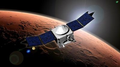
Spacecraft Flown To Just 78 Miles Above The Martian Surface
NASA’S Mars Atmosphere and Volatile Evolution has completed the first of five deep-dip maneuvers designed to gather measurements closer to the lower end of the Martian upper atmosphere.

“During normal science mapping, we make measurements between an altitude of about 93 miles and 3,853 miles above the surface,” said Bruce Jakosky, MAVEN principal investigator at the University of Colorado's Laboratory for Atmospheric and Space Physics in Boulder. “During the deep-dip campaigns, we lower the lowest altitude in the orbit, known as periapsis, to about 78 miles which allows us to take measurements throughout the entire upper atmosphere.”
The 16 miles altitude difference may not seem like much, but it allows scientists to make measurements down to the top of the lower atmosphere. At these lower altitudes, the atmospheric densities are more than ten times what they are at 93 miles.
“We are interested in the connections that run from the lower atmosphere to the upper atmosphere and then to escape to space,” said Jakosky. “We are measuring all of the relevant regions and the connections between them.”
The first deep dip campaign ran from Feb. 10 to 18. The first three days of this campaign were used to lower the periapsis. Each of the five campaigns lasts for five days allowing the spacecraft to observe for roughly 20 orbits. Since the planet rotates under the spacecraft, the 20 orbits allow sampling of different longitudes spaced around the planet, providing close to global coverage.
This month’s deep dip maneuvers began when team engineers fired the rocket motors in three separate burns to lower the periapsis. The engineers did not want to do one big burn, to ensure that they didn’t end up too deep in the atmosphere. So, they “walked” the spacecraft down gently in several smaller steps.
“Although we changed the altitude of the spacecraft, we actually aimed at a certain atmospheric density,” said Jakosky. “We wanted to go as deep as we can without putting the spacecraft or instruments at risk.”
Even though the atmosphere at these altitudes is very tenuous, it is thick enough to cause a noticeable drag on the spacecraft. Going to too high an atmospheric density could cause too much drag and heating due to friction that could damage spacecraft and instruments.
At the end of the campaign, two maneuvers were conducted to return MAVEN to normal science operation altitudes. Science data returned from the deep dip will be analyzed over the coming weeks. The science team will combine the results with what the spacecraft has seen during its regular mapping to get a better picture of the entire atmosphere and of the processes affecting it.
One of the major goals of the MAVEN mission is to understand how gas from the atmosphere escapes to space, and how this has affected the planet's climate history through time. In being lost to space, gas is removed from the top of the upper atmosphere. But it is the thicker lower atmosphere that controls the climate. MAVEN is studying the entire region from the top of the upper atmosphere all the way down to the lower atmosphere so that the connections between these regions can be understood.
MAVEN is the first mission dedicated to studying the upper atmosphere of Mars. The spacecraft launched Nov. 18, 2013, from Cape Canaveral Air Force Station in Florida. MAVEN successfully entered Mars’ orbit on Sept. 21, 2014.
MAVEN's principal investigator is based at the University of Colorado's Laboratory for Atmospheric and Space Physics. The university provided two science instruments and leads science operations, as well as education and public outreach, for the mission. NASA's Goddard Space Flight Center in Greenbelt, Maryland, manages the MAVEN project and provided two science instruments for the mission. Lockheed Martin built the spacecraft and is responsible for mission operations. The University of California at Berkeley's Space Sciences Laboratory also provided four science instruments for the mission. NASA's Jet Propulsion Laboratory in Pasadena, California, provides navigation and Deep Space Network support, as well as the Electra telecommunications relay hardware and operations.
(Image provided by NASA)
 Aero-FAQ: Dave Juwel's Aviation Marketing Stories -- ITBOA BNITBOB
 NTSB Prelim: Rutan Long-EZ
 ANN's Daily Aero-Term (12.05.25): Hazardous Weather Information
 Aero-News: Quote of the Day (12.05.25)
 Airborne-Flight Training 12.04.25: Ldg Fee Danger, Av Mental Health, PC-7 MKX


