WB-57s Put to Work Mapping Texas Flood | Aero-News Network
Aero-News Network
RSS icon RSS feed
podcast icon MP3 podcast
Subscribe Aero-News e-mail Newsletter Subscribe

Airborne Unlimited -- Most Recent Daily Episodes

Episode Date

Airborne-Monday

Airborne-Tuesday

Airborne-Wednesday Airborne-Thursday

Airborne-Friday

Airborne On YouTube

Airborne-Unlimited-07.07.25

Airborne-NextGen-07.08.25

AirborneUnlimited-07.09.25

Airborne-FlightTraining-07.10.25

AirborneUnlimited-07.11.25

Fri, Jul 11, 2025

WB-57s Put to Work Mapping Texas Flood

Classic Aircraft Adds Another Line to Its Long-Running Resume

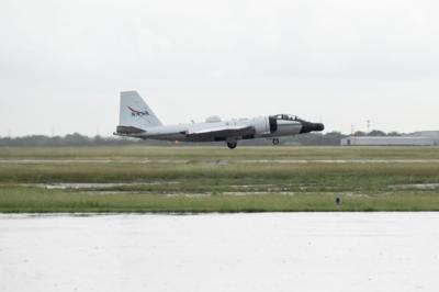
NASA’s old-school WB-57 got a workout this week with a novel mission for the classic aircraft: Emergency assessment of the devastated Texas Hill Country.

The high-altitude WB-57 has been a trusty workhorse for NASA over the years, flying since the early seventies. The WB-57 is a mid-wing, long-range aircraft capable of pulling off lengthy missions above 60,000 feet, derived from the old Martin B-57 bomber of yore. It’s a minor character in the greater happenings surrounding the Kerrville flood, but fans of classic and niche aircraft like seeing the old birds still earning their keep. As it happens, NASA deployed two WB-57s, dispatched under the NASA Disasters Response Coordination System, to help obtain crystal-clear imagery of the affected region. Cloud cover in the area has rendered much of the satellite data useless, so the WB-57s began aerial surveys with their DyNAMITE (Day/Night Airborne Motion Imager for Terrestrial Environments) sensor system. That tied into real-time collection and analysis on the ground, helping responders direct their efforts to where it’s most needed, without the need for post-flight processing.

NASA highlighted the use of their Uninhabited Aerial Vehicle Synthetic Aperture Radar (UAVSAR) aboard a Gulfstream III. That team plans to take observations of the Guadalupe, San Gabriel, and Colorado river basins through the rest of the week, thanks to its ability to penetrate vegetation. Their flights will help to define the extent of the flooding, crucial for damage assessments and future repairs.

All the data gathered is being coordinated with FEMA, the Texas Division of Emergency Management, and local responders to ensure it’s quickly delivered to those on the ground. Imagery collected will be sent to NASA’s Disaster Response Coordination System, and will eventually be disbursed for public reference via the NASA DIsasters Mapping Portal once they are finished.

FMI: www.nasa.gov

Advertisement

More News

NTSB Final Report: Aviat A1

Airplane Bounced About 3 Ft Then Touched Back Down And Then, With No Brakes Applied, The Airplane Began Veering To The Left Analysis: The pilot entered the airport traffic pattern >[...]

ANN's Daily Aero-Linx (07.08.25)

Aero Linx: British Microlight Aircraft Association (BMAA) The primary focus within all aviation activity is SAFETY. In all aspects of our sport SAFETY must come first, whether it b>[...]

Classic Aero-TV: Fly Corvair’s Reliable Engine Alternative

From SnF25 (YouTube Edition): William Wynne Builds Practical Aircraft Engines on the Corvair Platform Seeking an affordable alternative to the traditional aircraft engine options, >[...]

ANN FAQ: Contributing To Aero-TV

How To Get A Story On Aero-TV News/Feature Programming How do I submit a story idea or lead to Aero-TV? If you would like to submit a story idea or lead, please contact Jim Campbel>[...]

Classic Aero-TV: CiES Fuel-Quantity and e-Throttle Systems Praised

From 2023 (YouTube Edition): Bridge of CiES CiES Inc. is a Bend, Oregon-based designer and manufacturer of modular embedded aircraft systems and sensors. The company’s fuel-l>[...]

blog comments powered by Disqus


Advertisement

Advertisement

Podcasts

Advertisement

© 2007 - 2025 Web Development & Design by Pauli Systems, LC