Thu, Oct 30, 2014
Over 57,000 Square Miles Mapped And Analyzed
The Australian government says that it is progressing in its search for Malaysian Airlines Flight 370, a Boeing 777 that vanished in March of this year.
The search team, led by the Australian Transport Safety Bureau (ATSB), says it has mapped and analyzed over 150,000 square kilometers (approx. 57,000 sq miles) ... which it says is "sufficient area having been surveyed for the underwater search to take place." According to the update, the sea floor in the search area had never previously been mapped in detail. Before the sidescan sonar work to locate MH370 could begin, it was necessary to conduct a bathymetric survey to ensure that the equipment could be operated safely. The survey vessel Fugro Equator and the Chinese survey vessel Zhu Khezhen collaborated on survey operations, until Zhu Khezhen completed her assignment on September 20 and returned to China.
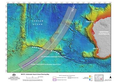
The ATSB says that while it is impossible to determine with certainty where the aircraft may have entered the water, the available data and analysis indicate that the most likely location lies close to a long but narrow arc in the southern Indian Ocean (where the aircraft last communicated with a ground station through a satellite). This is where the aircraft is assessed to have run out of fuel. Complex and ground-breaking technical analysis of the limited satellite communications data and aircraft flight information has been developed and refined since the disappearance of MH370. That work has concentrated on determining the area on the seventh arc that the aircraft was most likely to have reached, enabling a prioritized search effort.
After mapping, the ATSB says that Over 2,500 square kilometres (approx 965 sq miles) of the sea floor have been searched so far.
In addition to locating the aircraft, the underwater search aims to identify any crucial evidence (such as aircraft wreckage and flight recorders) to assist with the Malaysian investigation. The ATSB has utilized the data from the bathymetric survey work to prepare the initial plan for the underwater search, to be followed and referred to by all parties involved. The plan includes search timings, methods, procedures, safety precautions and search areas. The initial search areas have been allocated to the different vessels with the aim of positively identifying and mapping the debris field of MH370.
(ATSB Image)
More News
Outboard Section Of The Right Wing And The Right Flap Separated In Flight And The Airplane Impacted A Farm Field Analysis: The pilot was approaching his destination airport under i>[...]
Final Approach Fix The fix from which the final approach (IFR) to an airport is executed and which identifies the beginning of the final approach segment. It is designated on Gover>[...]
"Our choice of when to respond, how to respond and on which targets to respond is a consideration that we make every time... Netanyahu also noted that anyone attacking Israel &ldqu>[...]
Estimated (EST) When used in NOTAMs “EST” is a contraction that is used by the issuing authority only when the condition is expected to return to service prior to the e>[...]
Aero Linx: Coalition of Airline Pilots Associations (CAPA) The Coalition of Airline Pilots Associations (CAPA) is the world’s largest pilot trade association representing ove>[...]
 NTSB Final Report: Cessna 177B

