Skycatch Partners With DJI To Launch Commercial Drone Mapping App | Aero-News Network
Aero-News Network
RSS icon RSS feed
podcast icon MP3 podcast
Subscribe Aero-News e-mail Newsletter Subscribe

Airborne Unlimited -- Most Recent Daily Episodes

Episode Date

Airborne-Monday

Airborne-Tuesday

Airborne-Wednesday Airborne-Thursday

Airborne-Friday

Airborne On YouTube

Airborne-Unlimited-05.13.24

Airborne-NextGen-05.14.24

Airborne-Unlimited-05.15.24 Airborne-AffordableFlyers-05.16.24

Airborne-Unlimited-05.17.24

Thu, May 12, 2016

Skycatch Partners With DJI To Launch Commercial Drone Mapping App

Automates Data Capture With Latest DJI UAVs

Drone software company Skycatch has launched Commander, an iOS flight app for DJI drones. The app automates data capture with DJI's latest drones, turning them into professional mapping tools.

DJI maintains a 70% share of the $2 billion consumer drone market, and its aerial platforms are used by two­-thirds of businesses approved by the FAA to operate commercially. Skycatch built the app using DJI's open software development kit.

"The goal of DJI's SDK has always been to facilitate the creation of a robust ecosystem of apps, such as Commander," said Darren Liccardo, DJI Vice President of Engineering, Systems and Applications. "Professionals know best what the use case is for our aerial platforms in their specific vertical sectors. Skycatch's developers have made optimal use of our open APIs with their innovative mapping and modeling application."

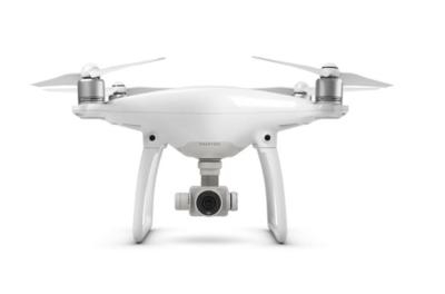
The app launches with support for DJI Phantom 3 Advanced and Professional, Inspire 1, and the new Phantom 4 drones.

DJI drones and Apple iOS devices deliver unparalleled user experiences for both home and commercial users. Commander combines the two with streamlined data capture to further refine the user experience, creating a powerful partnership of aerial data and analytics tools.

With Commander, users simply outline the area they want to map and the app automatically generates the optimal route and autonomously flies it for them. Images are processed into high-­resolution maps and 3D models accessed in the Skycatch Dashboard. Professionals in construction, mining, and energy use Dashboard to inform business decisions and carry out functions such as calculating assets, planning logistics, and reporting progress.

"Collaboration is essential in helping industry professionals evolve with technology," said Skycatch CEO Christian Sanz. "Commander opens the doors of aerial data capture so any project manager can become a drone pilot and any job site can benefit from new data sets and improved workflows."

With step­-by-­step in­-app guidance, automated features for flying, and direct access to processed imagery via web browser, Commander is putting aerial data just a few taps away.

(Source: Skycatch news release. Image from file)

FMI: www.skycatch.com

Advertisement

More News

ANN's Daily Aero-Term (05.17.24): Very High Frequency

Very High Frequency The frequency band between 30 and 300 MHz. Portions of this band, 108 to 118 MHz, are used for certain NAVAIDs; 118 to 136 MHz are used for civil air/ground voi>[...]

ANN's Daily Aero-Linx (05.17.24)

Aero Linx: Aviation Suppliers Association Established February 25, 1993, the Aviation Suppliers Association (ASA), based in Washington, D.C., is a not-for-profit association, repre>[...]

ANN FAQ: Submit a News Story!

Have A Story That NEEDS To Be Featured On Aero-News? Here’s How To Submit A Story To Our Team Some of the greatest new stories ANN has ever covered have been submitted by our>[...]

Classic Aero-TV: ANN Visits Wings Over The Rockies Exploration Of Flight

From 2021 (YouTube Version): Colorado Campus Offers aVariety Of Aerospace Entertainment And Education Wings over the Rockies Exploration of Flight is the second location for the Wi>[...]

Airborne Affordable Flyers 05.16.24: PRA Runway, Wag-Aero Sold, Young Eagles

Also: Paramotor Champ's, Electric Ultralight, ICON BK Update, Burt Rutan at Oshkosh! The Popular Rotorcraft Association is reaching out for help in rebuilding their private runway >[...]

blog comments powered by Disqus


Advertisement

Advertisement

Podcasts

Advertisement

© 2007 - 2024 Web Development & Design by Pauli Systems, LC