ESA Drop-Tests Unmanned 'Space Plane' | Aero-News Network
Aero-News Network
RSS icon RSS feed
podcast icon MP3 podcast
Subscribe Aero-News e-mail Newsletter Subscribe

Airborne Unlimited -- Most Recent Daily Episodes

Episode Date

Airborne-Monday

Airborne-Tuesday

Airborne-Wednesday Airborne-Thursday

Airborne-Friday

Airborne On YouTube

Airborne-Unlimited-11.10.25

AirborneNextGen-
11.11.25

Airborne-Unlimited-11.12.25

Airborne-Unlimited-11.06.25

AirborneUnlimited-11.07.25

LIVE MOSAIC Town Hall (Archived): www.airborne-live.net

Thu, Jun 26, 2014

ESA Drop-Tests Unmanned 'Space Plane'

Recovery Crew Conducts Practice Off The Coast Of Italy

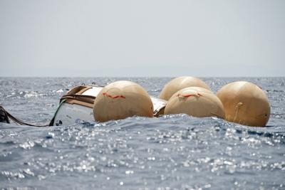
The ship and crew aiming to recover Europe’s unmanned IXV spacecraft in November had a practice run off the coast of Tuscany, Italy Monday. They retrieved a prototype of the suborbital IXV Intermediate eXperimental Vehicle, the same model flown last year in a splashdown test off the east coast of Sardinia.

A crane dropped the two-metric-ton vehicle into the water for the crew to practice the tricky maneuvers they will use when the real thing splashes down in the Pacific Ocean later this year. The rehearsal even allowed for an upside-down splashdown.

A crew from the Italian company NERI were operating the recovery ship Nos Aries while the prototype was carefully hoisted aboard and into its container. This model, its work done, will now be taken to ESA’s Technical Centre in the Netherlands for display.

Launched later this year on ESA’s Vega rocket from Kourou, French Guiana, IXV will test technologies and systems for Europe’s future autonomous atmospheric reentry vehicles. Descending on its suborbital path, as if returning from low orbit, IXV will use its body to generate lift for flying, controlled only by aerodynamic flaps and thrusters.

It is packed with new technology to collect information on aerodynamics, aerothermodynamics, materials, structures, mechanisms, guidance, navigation, control and avionics.

The experimental flight will end with IXV transmitting its precious information before splashing down into the most remote region of the Pacific, where Nos Aries will be waiting to retrieve it.

Setting off in mid-summer, Nos Aries will leave Italy to cross the Mediterranean Sea and the Atlantic. The specialist crew will board in Panama for the month-long journey through the Panama Canal and Pacific. Before launch, the ship will release weather balloons to check the wind conditions over the Pacific to provide information on IXV’s descent path. If sea conditions allow the launch to go ahead, Nos Aries will receive the flight data from IXV’s 300 sensors during descent and then pick up the beacon signals to pinpoint the craft after splashdown.

Divers on speedboats will approach the floating craft and then stand back as robotic sniffers check for residual propellant fumes. On the all-clear, the recovery cranes will carefully lift IXV to safety before the fuel tank is cleaned out for the journey home to Europe.

(Image provided by ESA)

FMI: www.esa.int

Advertisement

More News

ANN FAQ: Contributing To Aero-TV

How To Get A Story On Aero-TV News/Feature Programming How do I submit a story idea or lead to Aero-TV? If you would like to submit a story idea or lead, please contact Jim Campbel>[...]

Classic Aero-TV: Bob Hoover At Airventure -- Flight Test and Military Service

From 2011 (YouTube Edition): Aviation's Greatest Living Legend Talks About His Life In Aviation (Part 5, Final) ANN is pleased to offer you yet another snippet from the public conv>[...]

Aero-News: Quote of the Day (11.12.25)

“All Air Traffic Controllers must get back to work, NOW!!! Anyone who doesn’t will be substantially ‘docked. For those Air Traffic Controllers who were GREAT PATR>[...]

ANN's Daily Aero-Linx (11.12.25)

Aero Linx: American Navion Society Welcome to the American Navion Society. Your society is here to support the Navion community. We are your source of technical and operating infor>[...]

ANN's Daily Aero-Term (11.12.25): Glideslope Intercept Altitude

Glideslope Intercept Altitude The published minimum altitude to intercept the glideslope in the intermediate segment of an instrument approach. Government charts use the lightning >[...]

blog comments powered by Disqus


Advertisement

Advertisement

Podcasts

Advertisement

© 2007 - 2025 Web Development & Design by Pauli Systems, LC