WingX Pro7 Version 6.2 Adds Advanced Features | Aero-News Network
Aero-News Network
RSS icon RSS feed
podcast icon MP3 podcast
Subscribe Aero-News e-mail Newsletter Subscribe

Airborne Unlimited -- Most Recent Daily Episodes

Episode Date

Airborne-Monday

Airborne-Tuesday

Airborne-Wednesday Airborne-Thursday

Airborne-Friday

Airborne On YouTube

Airborne-Unlimited-05.19.25

Airborne-NextGen-05.20.25

AirborneUnlimited-05.21.25

Airborne-AffordableFlyers-05.22.25

AirborneUnlimited-05.23.25

Wed, Mar 14, 2012

WingX Pro7 Version 6.2 Adds Advanced Features

Passive RADAR Altimeter, Flight Simulation Mode, and Real-Time Descent Profile Information In Latest Version

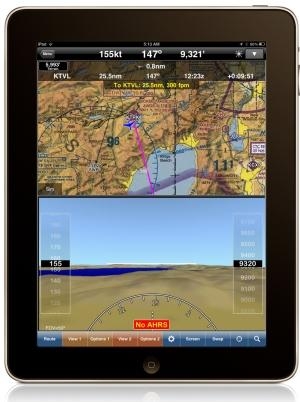
The latest version of WingX Pro7 features new Passive RADAR Altimeter technology for iPad and iPhone. The Passive RADAR Altimeter displays terrain elevation and the aircraft’s approximate AGL; together with Dynamic Terrain Overlays and Synthetic Vision, Hilton Software says WingX Pro7 continues to significantly reduce the risk of Controlled Flight Into Terrain (CFIT). WingX Pro7 Version 6.2 also adds Flight Simulation Mode that enables pilots to pre-fly an entire flight, portion of a flight, or an approach into an airport. Version 6.2’s Moving Map integrates Descent Profile Information that displays descent and landing information to the destination airport or runway touchdown zone.

“We are driven by our desire to increase aviation safety and efficiency," said Hilton Software CEO Dr. Hilton Goldstein. "Our new ‘no hardware, no wires’ Passive RADAR Altimeter solution is revolutionary in mobile aviation computing. WingX Pro7’s new Simulation Mode gives pre-flight a whole new meaning by driving all the pieces of WingX Pro7 including the Moving Map and Synthetic Vision. This enables pilots to simulate an approach into an airport while viewing and interacting with WingX Pro7 as though the approach was actually being flown. Instead of developing a simulator that runs on a desktop, we built flight simulation into the iPad. Another great feature in WingX Pro7 is the addition of Descent Profile Information that not only displays VNAV-like information, but also displays which runway the aircraft is approaching thereby reducing the risk of a runway incursion. We’ve also added tighter integration with Google Earth™ that enables pilots to view their planned route in Google Earth.”

WingX Pro7 Version 6.2 is a free update for registered users and is available now for download from the App Store and iTunes. (Image provided by Hilton Software)

FMI: www.hiltonsoftware.com

Advertisement

More News

NTSB Prelim: Lee Aviation LLC JA30 SuperStol

A Puff Of Smoke Came Out From The Top Of The Engine Cowling Followed By A Total Loss Of Engine Power On May 9, 2025, about 1020 mountain daylight time, an experimental amateur-buil>[...]

Classic Aero-TV: Curtiss Jenny Build Wows AirVenture Crowds

From 2022 (YouTube Edition): Jenny, I’ve Got Your Number... Among the magnificent antique aircraft on display at EAA’s AirVenture 2022 was a 1918 Curtiss Jenny painstak>[...]

ANN's Daily Aero-Term (05.30.25): Very High Frequency (VHF)

Very High Frequency (VHF) The frequency band between 30 and 300 MHz. Portions of this band, 108 to 118 MHz, are used for certain NAVAIDs; 118 to 136 MHz are used for civil air/grou>[...]

Aero-News: Quote of the Day (05.30.25)

“From approximately November 2021 through January 2022, Britton-Harr, acting on behalf of AeroVanti, entered into lease-purchase agreements for five Piaggio-manufactured airc>[...]

ANN's Daily Aero-Term (05.31.25): Microburst

Microburst A small downburst with outbursts of damaging winds extending 2.5 miles or less. In spite of its small horizontal scale, an intense microburst could induce wind speeds as>[...]

blog comments powered by Disqus


Advertisement

Advertisement

Podcasts

Advertisement

© 2007 - 2025 Web Development & Design by Pauli Systems, LC