Ingenuity Has Thus far Climbed To A New Record Altitude Of 40 Feet
Ask any space explorer, and they’ll have a favorite photo or two from their mission. For Kevin Hand, a scientist at NASA’s Jet Propulsion Laboratory in Southern California and co-lead of the Perseverance rover’s first science campaign, his latest favorite is a 3D image of low-lying wrinkles in the surface of Jezero Crater.
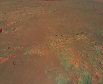
The science team calls this area “Raised Ridges.” NASA’s Ingenuity Mars Helicopter captured the two shots for this stereo image on July 24 during its 10th flight.
Ingenuity captured the images during its most complex flight yet. After taking off from its seventh airfield, it climbed to a new record altitude of 40 feet. The helicopter then made four heading changes and took 10 images with the rotorcraft’s color camera before landing at a new airfield. The 3D image was created by combining two of those images, offering the rover team a richer perspective as they plan the next steps in their science campaign.
“In 3D it almost feels like you can reach out and touch the Raised Ridges,” said Hand. “But along with its immersive beauty, the image provides great detail. If you look closely, you can see some curious lines across the surfaces of several rocks. Are these just made by eons of wind and dust blowing over the rocks, or might those features tell the story of water? We just don’t know yet.”
Those details are important. In their search for signs of ancient life on Mars, the team is considering drilling a rock or sediment sample in the Raised Ridges, which would take several Martian days, or sols, of driving to reach. With Ingenuity’s images, the rover team now has a much better idea of what to expect if they were to go there and the science value of doing so. In the weeks to come, the science team will pour over this and other 3D images from Ingenuity and debate the merits of such a visit.
“Since landing at Jezero Crater, it’s clear to all of us that there is an abundance of geologic riches for us to explore. It’s a good problem to have,” said Ken Williford, deputy project scientist for Perseverance at JPL. “These aerial previews from Ingenuity provide the kind of actionable data that allow us to whittle down our options and get on with the business of exploring our corner of Mars.”
A key objective for Perseverance’s mission on Mars is astrobiology, including the search for signs of ancient microbial life. The rover will characterize the planet’s geology and past climate, pave the way for human exploration of the Red Planet, and be the first mission to collect and cache Martian rock and regolith (broken rock and dust).
Subsequent NASA missions, in cooperation with ESA (European Space Agency), would send spacecraft to Mars to collect these sealed samples from the surface and return them to Earth for in-depth analysis.
 NTSB Prelim: Piper PA-23

